Consultation closed
The cycleway is designed to provide a safe connection for local cycling trips through Harewood, Bishopdale and Papanui to schools, shops, businesses and parks. It also provides a connection to the airport and the approximately 7000 people who work on the airport campus.
At its western end, Wheels to Wings – Papanui ki Waiwhetū will connect with the Johns Road cycle and pedestrian underpass, linking through to the commercial areas surrounding the airport, and to McLeans Island Road via the Johns Road shared path. This will be a good connection route for the large number of people working in the commercial area near the airport.
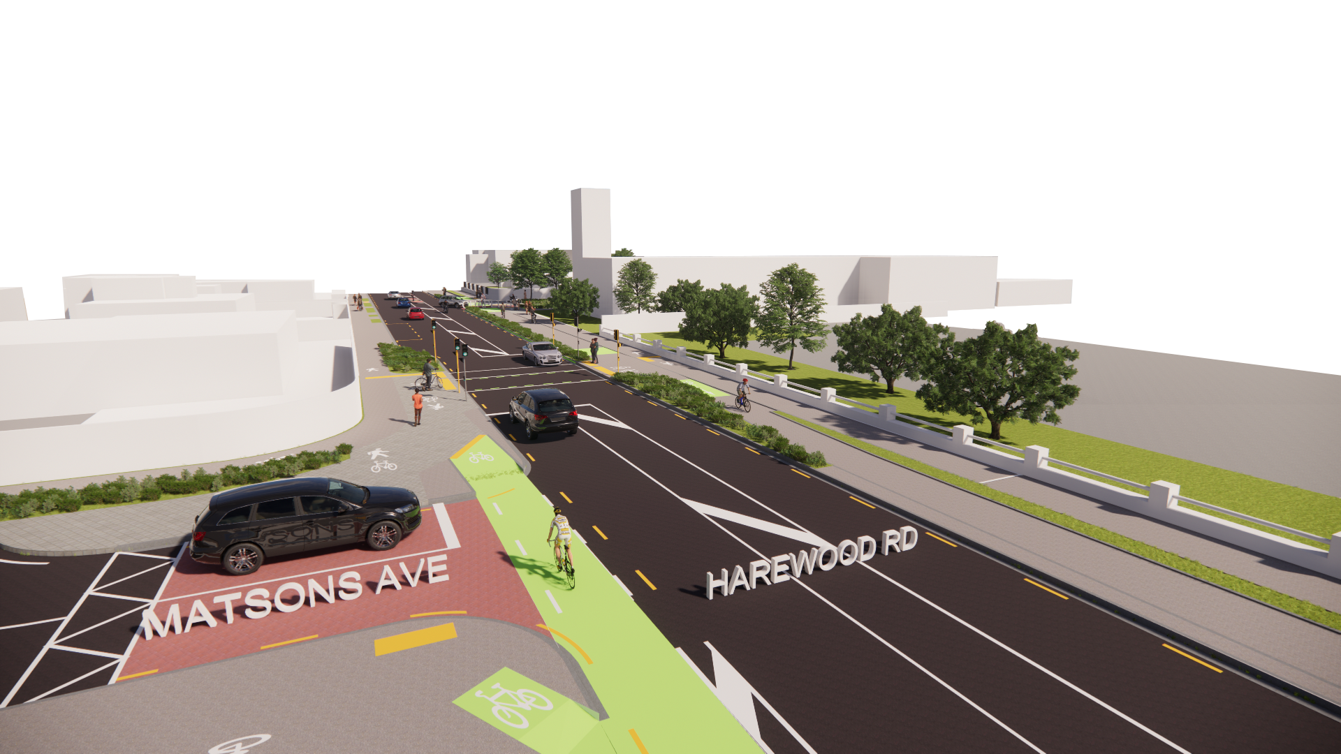
At its eastern end, Wheels to Wings Papanui ki Waiwhetū connects directly to the Northern Line cycle route and the future Nor’West Arc cycleway which is currently planned along Matsons Avenue (this will be consulted on later in the year).
Projects updates
A key decision has been made regarding the next steps for the Wheels to Wings Papanui ki Waiwhetū cycleway.
Since receiving confirmation that a government funding contribution is unlikely to be provided for Wheels to Wings, the elected Council has been discussing the next steps for the cycleway during the 2025-2026 Annual Plan process.
At an Annual Plan meeting on Tuesday 10 December 2024 the elected Council approved a staged construction approach for the Wheels to Wings Major Cycle Route (MCR):
- Delivering the connection at the eastern end of Harewood Road, between the railway line and Matsons Avenue, to link the Northern Line and Nor’West Arc MCRs .
- Adding a signalised pedestrian crossing on Harewood Road, between Matsons Avenue and Chapel Street
Installing a signalised pedestrian crossing and footpath widening improvements around Harewood School, Te Kura o Tāwera . - Installing traffic lights at the Harewood Road, Gardiners Road and Breens Road intersection .
- The remaining construction programme is yet to be finalised and will be confirmed through future Annual Plan or Long Term Plan processes.
- We're doing some investigation work around Harewood Road between 25 March and early May 2024.
- These works are to confirm the location of services under the road to help plan the most efficient construction approach for the following large infrastructure projects:
- A Harewood Road watermain renewal
- New traffic lights at the Langdons Road / Greers Road intersection
- The Wheels to Wings Papanui ki Waiwhetū Major Cycle Route
- Construction of the three projects is not programmed to begin until later in 2024.
- We’re continuing to work with Waka Kotahi NZ Transport Agency (NZTA) regarding their funding contribution to the cycleway.
- Investigation work is required to understand the underground service location and condition, as well as any potential clashes or risks to construction.
- As these projects are located in the same area, we're using this opportunity to combine our investigation work.
- Please see the map and timeline below for more information about the location and traffic impact of our investigation work.
- We know this work can be disruptive, and we appreciate your co-operation and understanding.
- You can read more information about these investigations on our Working in Bishopdale project page or in our Newsline(external link) story.


- We’re continuing to work on the detailed design.
- We’re meeting with the last few residents and businesses along the route to discuss issues and finalise the detailed design.
- You’ll start to see our contractors and surveyors onsite undertaking investigations needed to complete the detailed design.
- We expect construction to begin sometime in 2024, however, the construction phasing and timing of the route are yet to be determined.
- We’re continuing to work with Waka Kotahi regarding their funding contribution to this project.
- The resolution proposed for the 2023/24 Annual Plan delays construction starting for 12 months.
- In the meantime, detailed design will continue to ensure that all the unresolved design issues and concerns that were raised as part of the hearing process are addressed. The scheme design has been completed and approved via a resolution of the Council.
- The required business case for Waka Kotahi NZ Transport Agency funding has been submitted for review and approval. This is still a work in progress.
- Waka Kotahi has advised that funding availability in this National Land Transport Fund (NLTF) period is minimal and that the likelihood of subsidy support has changed from possible to unlikely. This may change in the 2024-34 NLTF period.
We're holding three community information days to share with you what we heard during the consultation, our responses, the changes based on your feedback and further information on the proposed cycleway (including other options we've looked at). You are able to book your spot at one of these sessions and view new updates here.
We’re postponing the Wheels to Wings – Papanui ki Waiwhetū cycleway information days due to Covid-19 restrictions. We apologise for the inconvenience and we’ll look to reschedule as soon as possible.
We were planning to hold the information days on Thursday 2 and Friday 3 September.
It’s really important that we have a conversation with the community about the changes we’ve made and the different design concepts looked at, so we’re waiting until we can have these discussions in person.
As there has been a high level of engagement with this project it is important that we have the information days when people feel comfortable attending and have the time to consider the information. There will still be an opportunity to give further feedback as planned on the additional design work we’ve done when we hold the information days at a later date.
The other meetings to be rescheduled are:
- a briefing for the hearings panel;
- a community board workshop; and
- a hearing to consider oral submissions and make a recommendation to the Urban Development and Transport Committee.
Consultation on Wheels to Wings – Papanui ki Waiwhetū Major Cycleway has now closed. People were able to provide feedback from 25 January to 15 March.
During this time we heard from 1348 submissions from individuals and groups. Many submitters have lived, or worked, in the area for a long time and have provided us with very detailed feedback. Thanks again for taking the time to consider the cycleway proposal. You can read all feedback in the document library.
Themes of the feedback
Submitters who support the cycleway identified better safety for people biking, a safe route for children to get to school, and the positive impact on climate change as their key considerations.
Submitters who don’t support the cycleway identified loss of parking, increased traffic congestion as a result of reducing four lanes to two, and the cost of the project as their key issues.
Other issues raised by those not in support include:
- Safety – property access, driver behaviour and cycleway design
- Safety concerns at Harewood/Greers intersection
- Bishopdale roundabout – design of the roundabout and trees
- Access for emergency services
- Bus stop changes
- How the wider network will function (including Langdons Road)
- Alternative route suggestions and design options
There was widespread support for signalising the Harewood/Gardiners/Breens intersection.
Community consultation
The Wheels to Wings – Papanui ki Waiwhetū route can be divided into the following six sections:
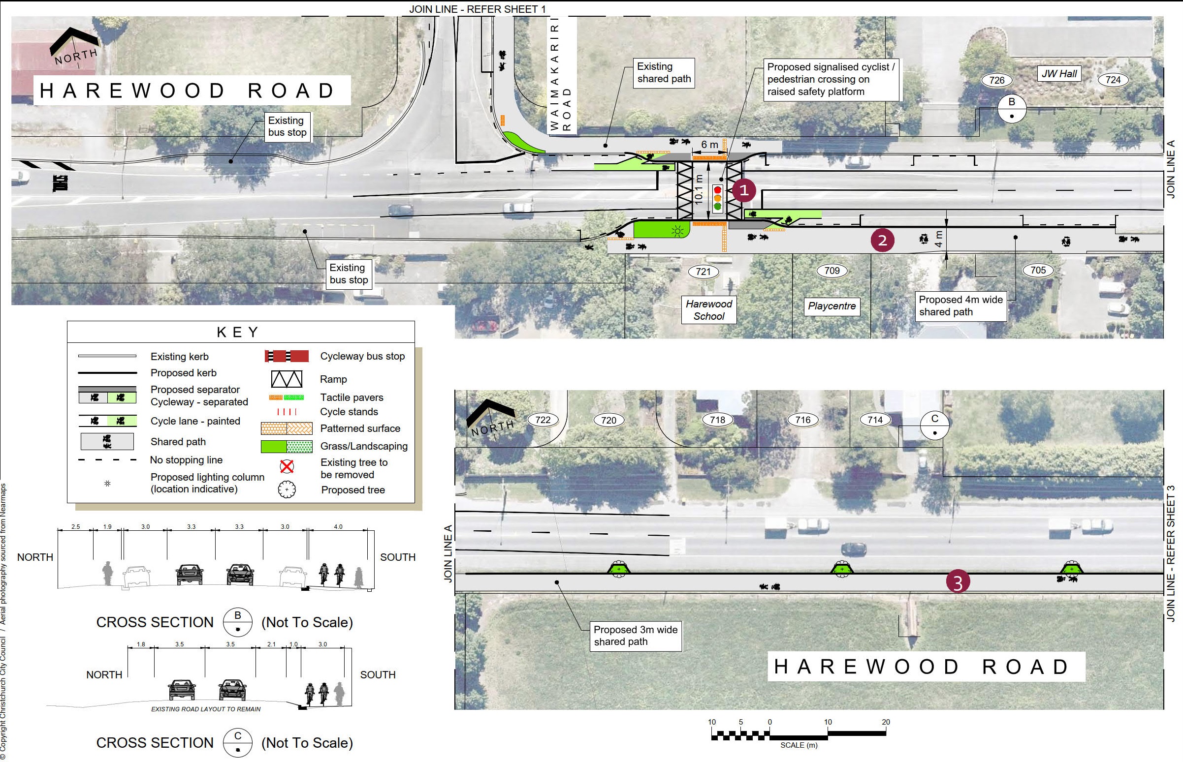
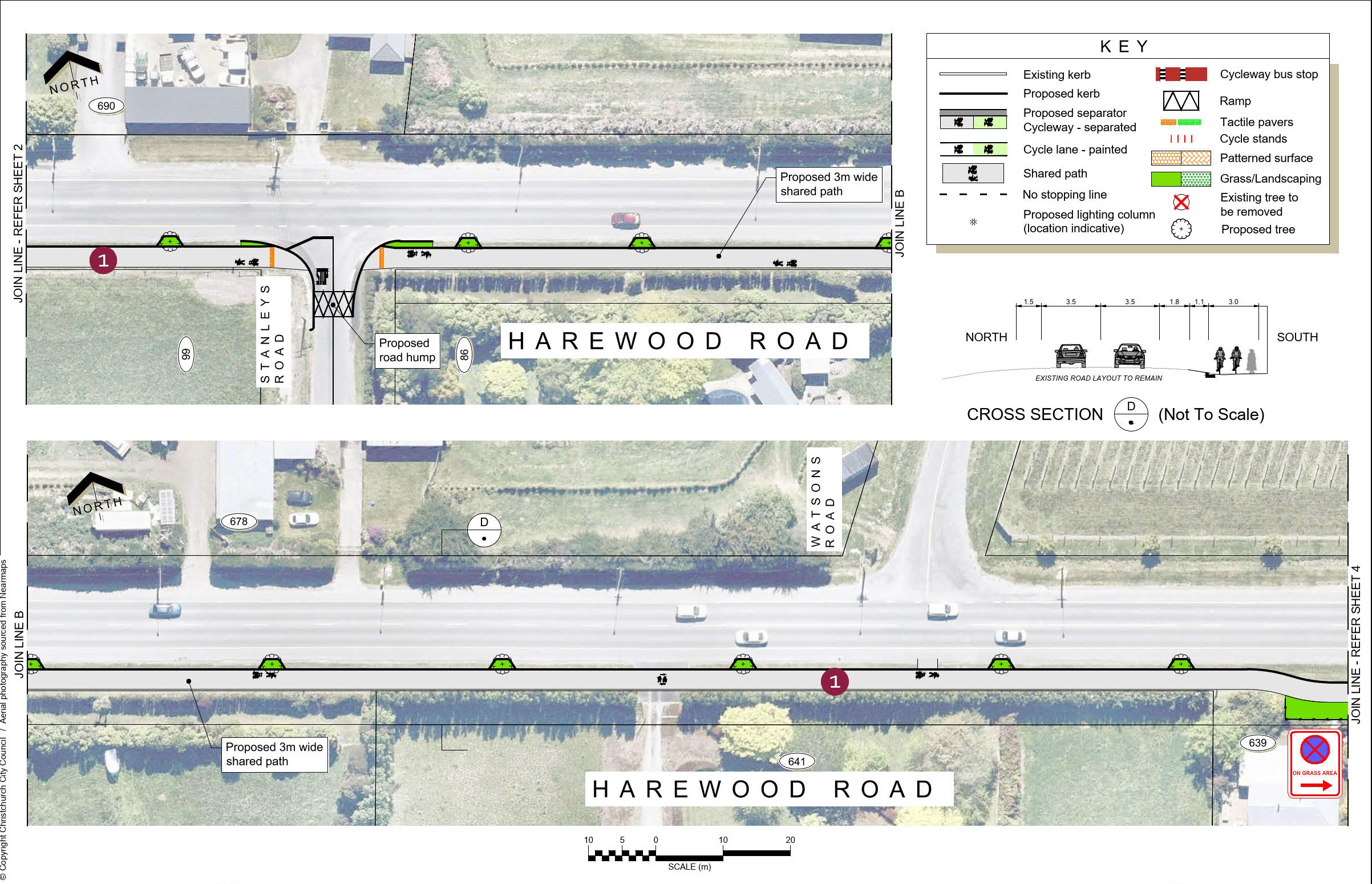
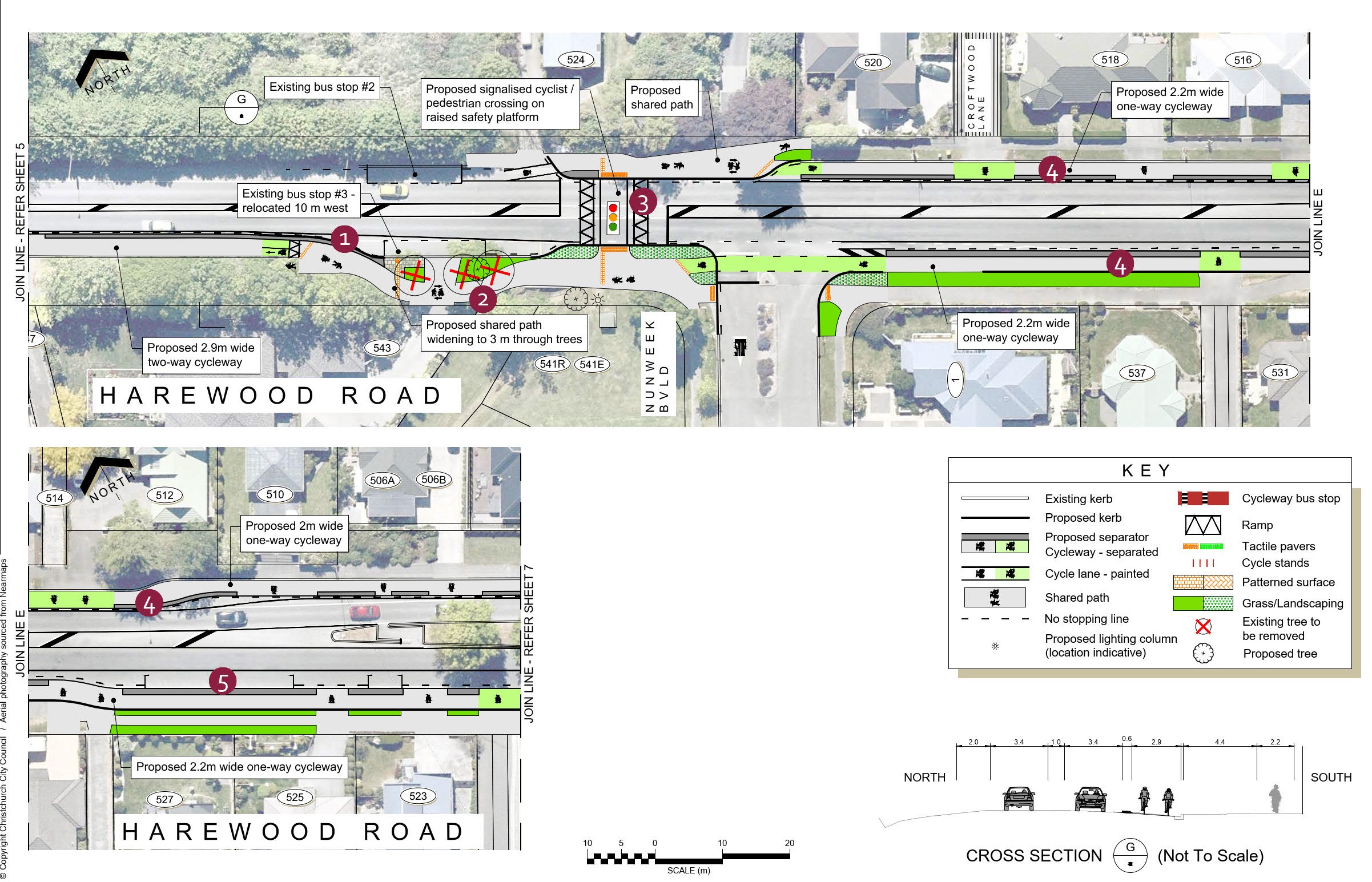
- Whitchurch Place, Waimakariri Road, and Harewood Road up to Nunweek Boulevard Widening of the existing shared paths and construction of a two-way separated cycleway between Kilmuir Lane and Nunweek Boulevard, along with improved road crossings and intersections.
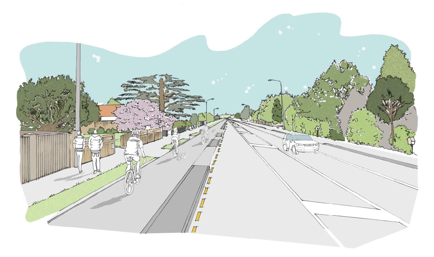
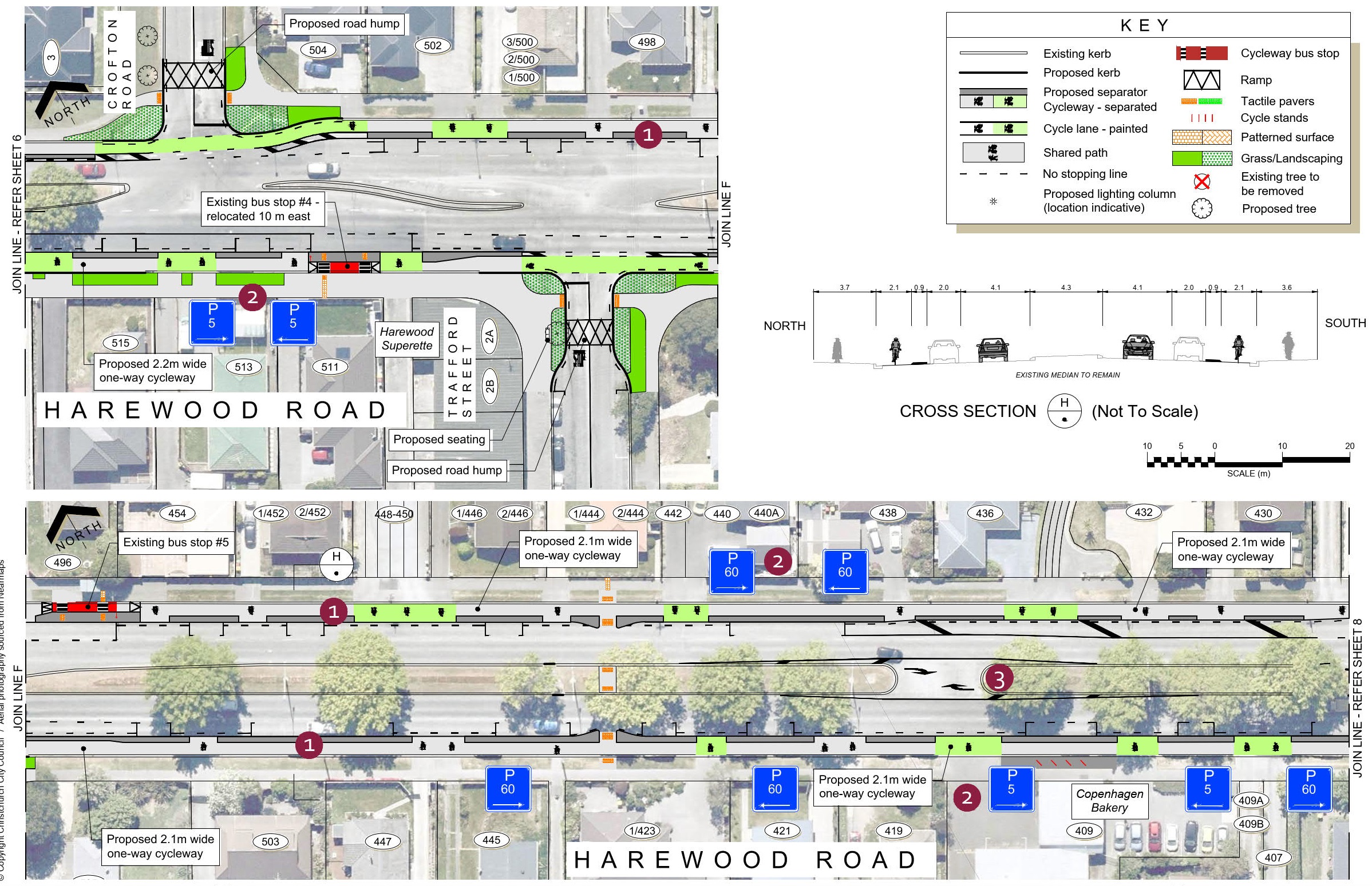
- Harewood Road from Nunweek Boulevard to the Bishopdale Roundabout One-way separated cycleways on each side of the road. This will require the removal of one traffic lane in each direction along the four-lane section of Harewood Road and the removal of some on- street parking.
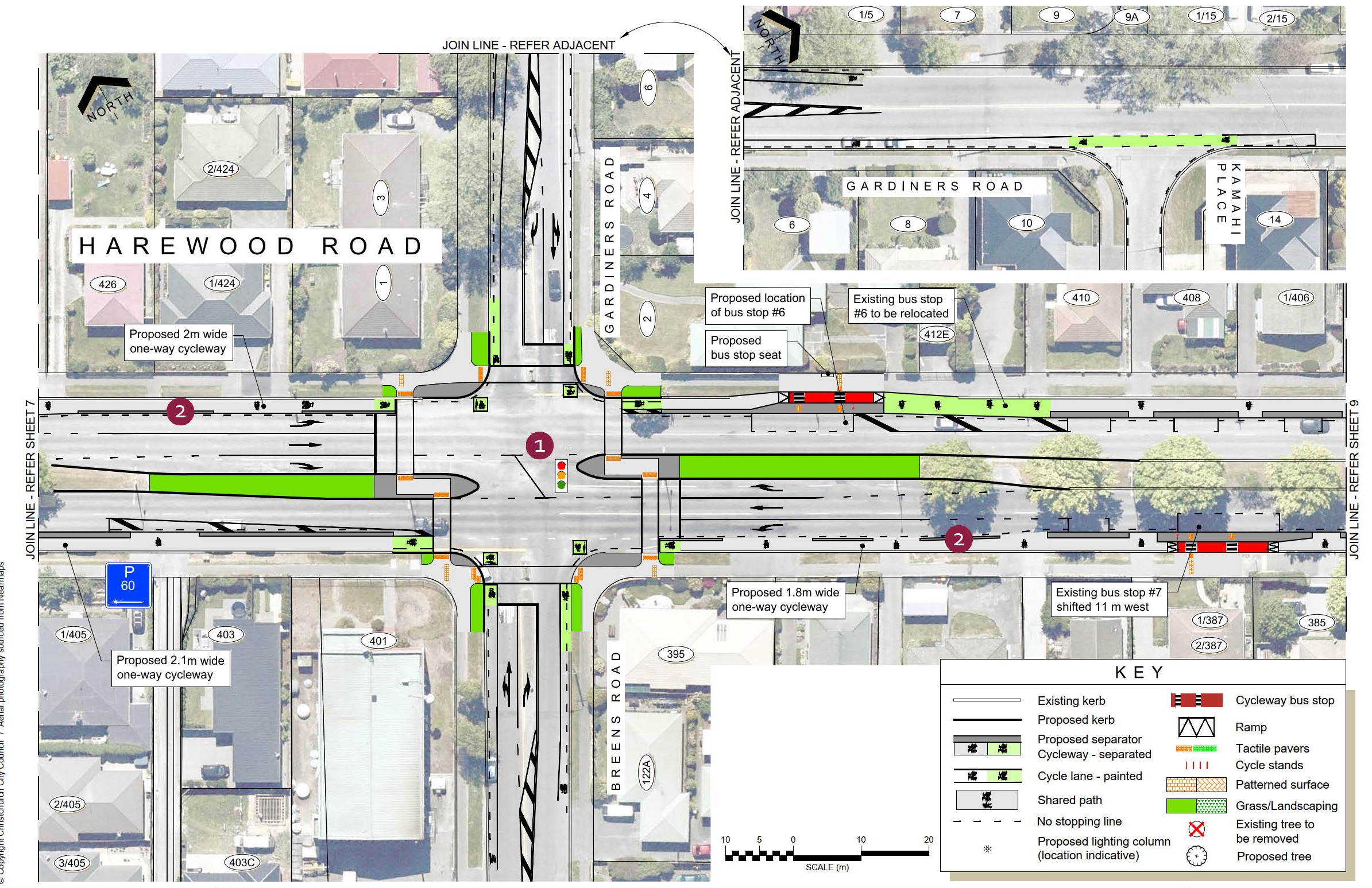
- Bishopdale Roundabout New traffic signals at the east and west ends of the Bishopdale Roundabout will provide crossings for people cycling and walking through the roundabout and across Harewood Road, as well as controlling vehicles coming into the roundabout from Harewood Road.
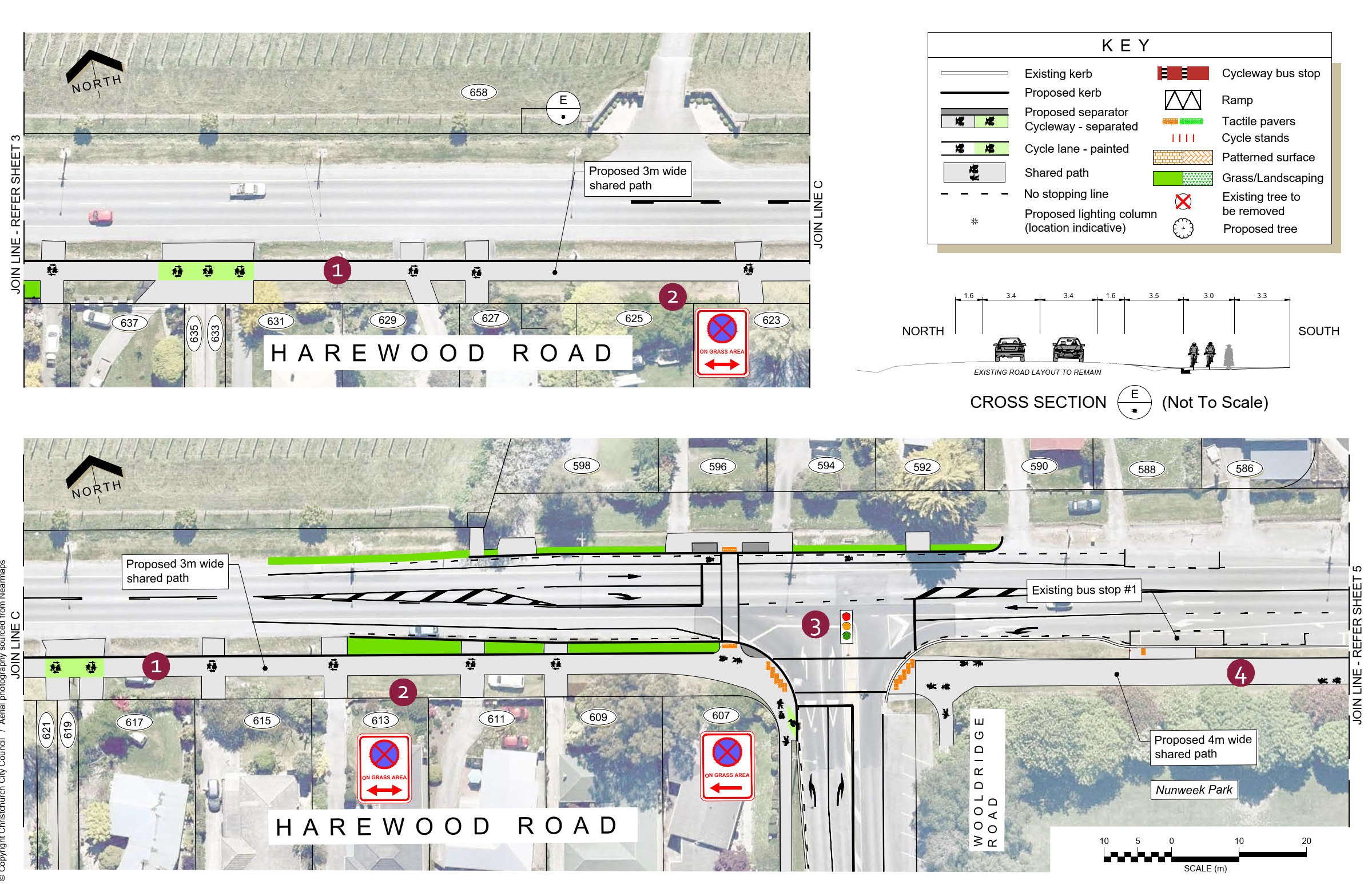
- Harewood Road from the Bishopdale Roundabout to Greers Road A two-way separated cycleway is proposed on the northern side of Harewood Road. This will require the removal of adjacent on- street parking and one traffic lane. Additional on-street parking will be provided on the southern side of the central median.
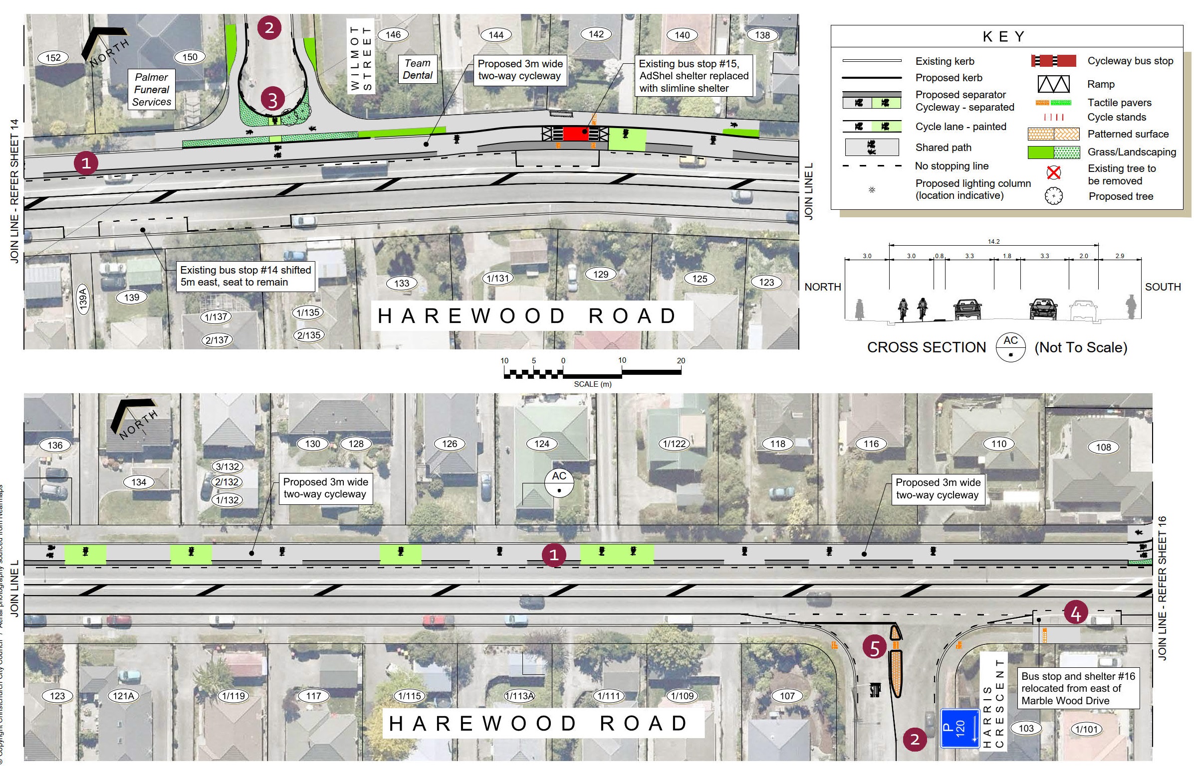
- Harewood Road from Greers Road to Matsons Avenue A two-way separated cycleway is proposed on the northern side of Harewood Road, removing the adjacent on-street parking. Some restrictions to vehicle access at side roads are proposed.
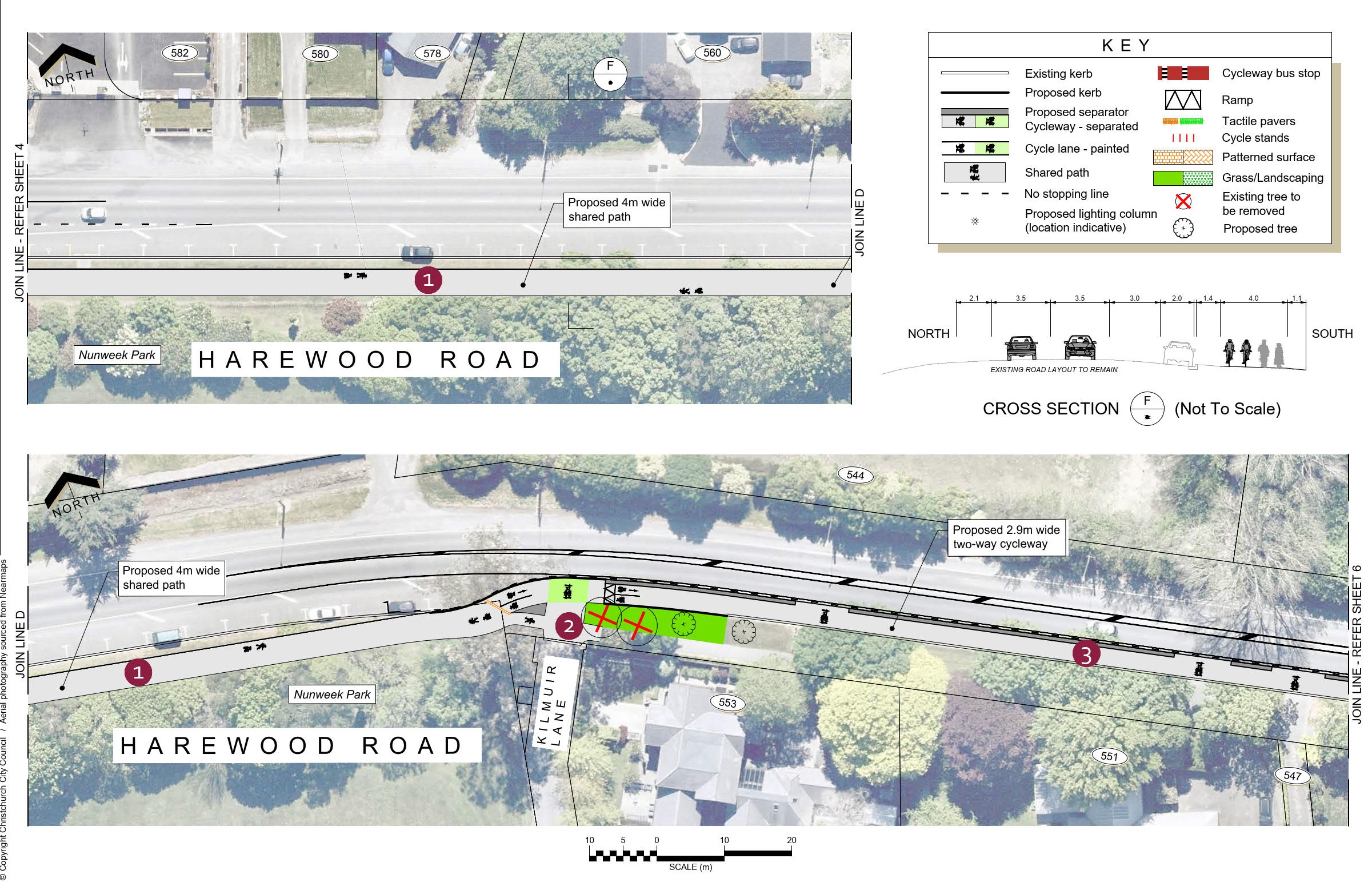
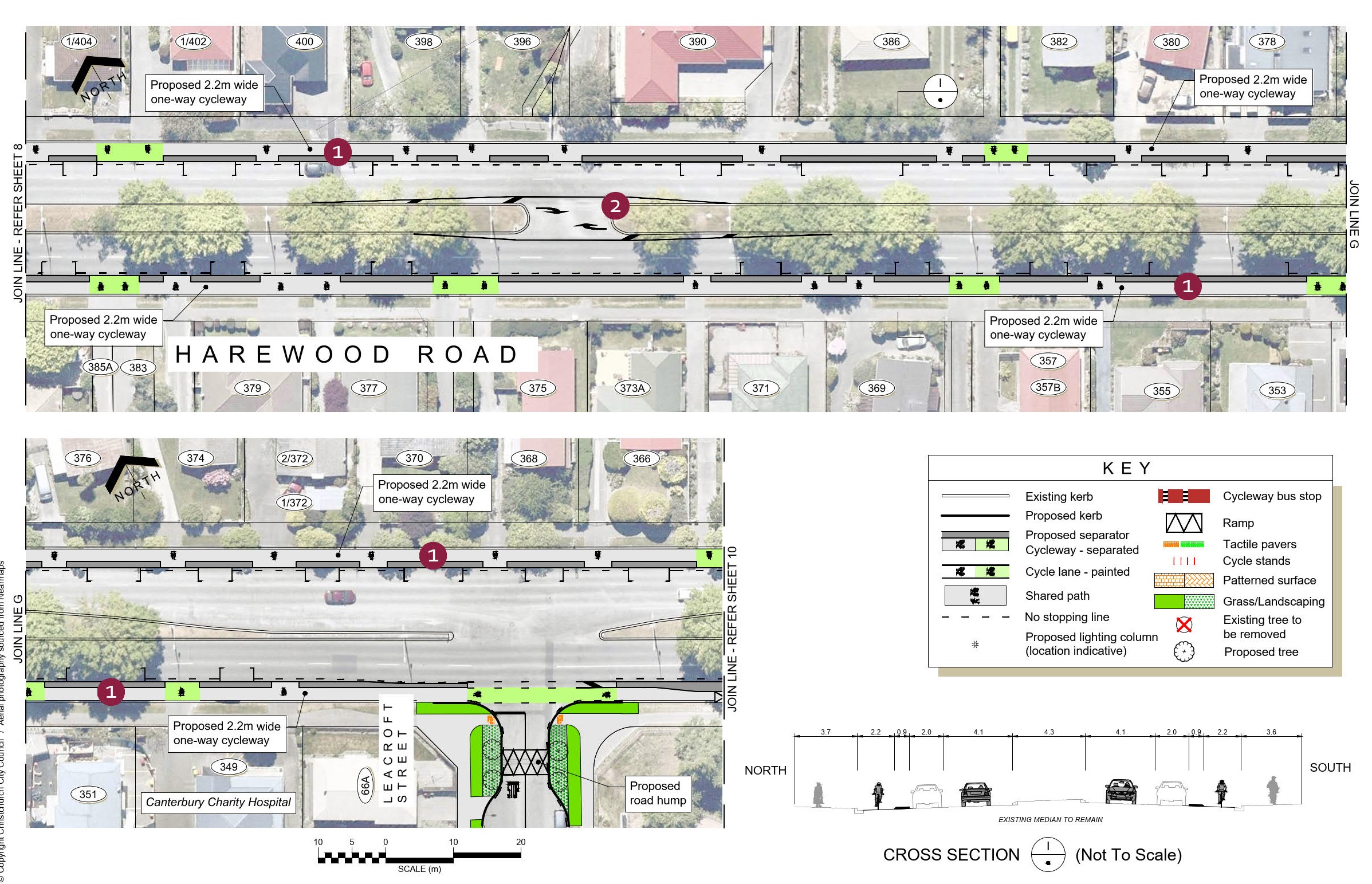
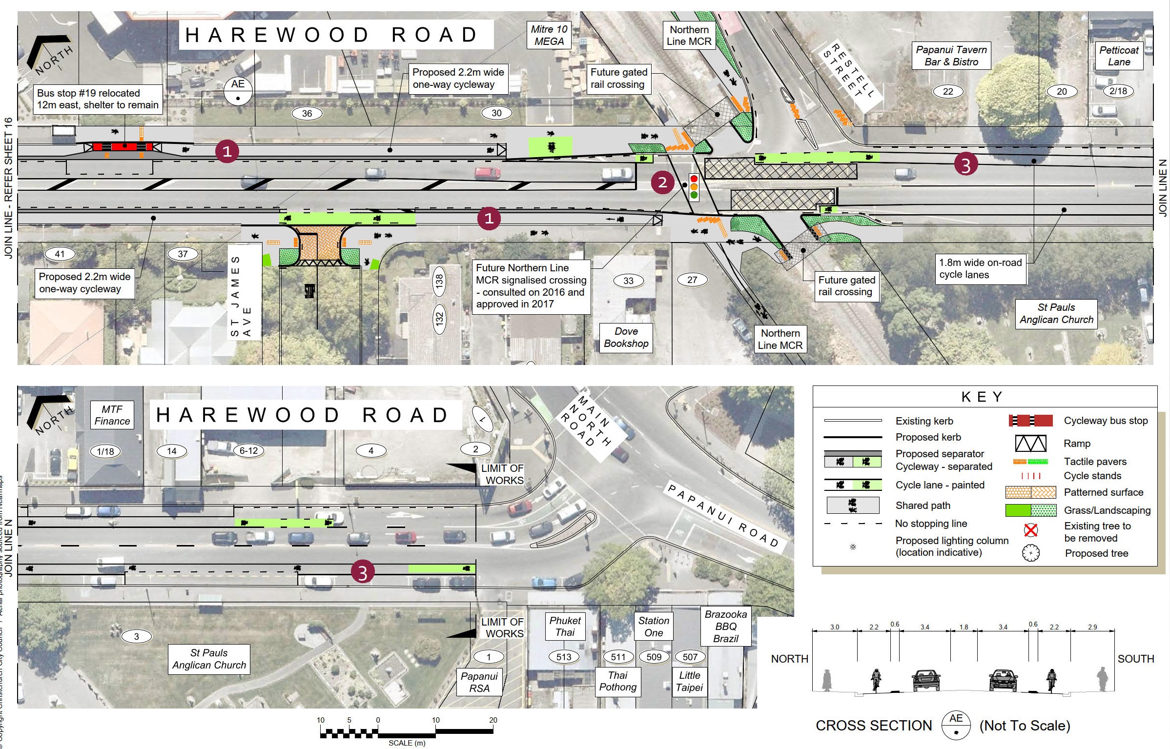
- Harewood Road from Matsons Avenue to Northern Line One-way separated cycleways are proposed on each side of Harewood Road. This will result in the removal of on-street parking on both sides of the road.
Key changes:
- Harewood Road reduced from four lanes to two lanes.
- New traffic signals at Harewood/Gardiners/Breens intersection and Wooldridge/HarewoodRoad intersection.
- Traffic signals at each end of the Bishopdaleroundabout.
- New signalised crossings at HarewoodPrimary School, Nunweek Boulevard, and Harewood Road near Matsons Avenue.
- Changes to vehicle access on Wilmot Street, Sails Street and Chapel Street at Harewood Road.
Route maps
Map 1 Waimakariri Road end of Harewood Road [PDF, 11 MB]
Map 2 mid section of Harewood Road [PDF, 10 MB]
Map 3 east end of Harewood Road [PDF, 8.5 MB]
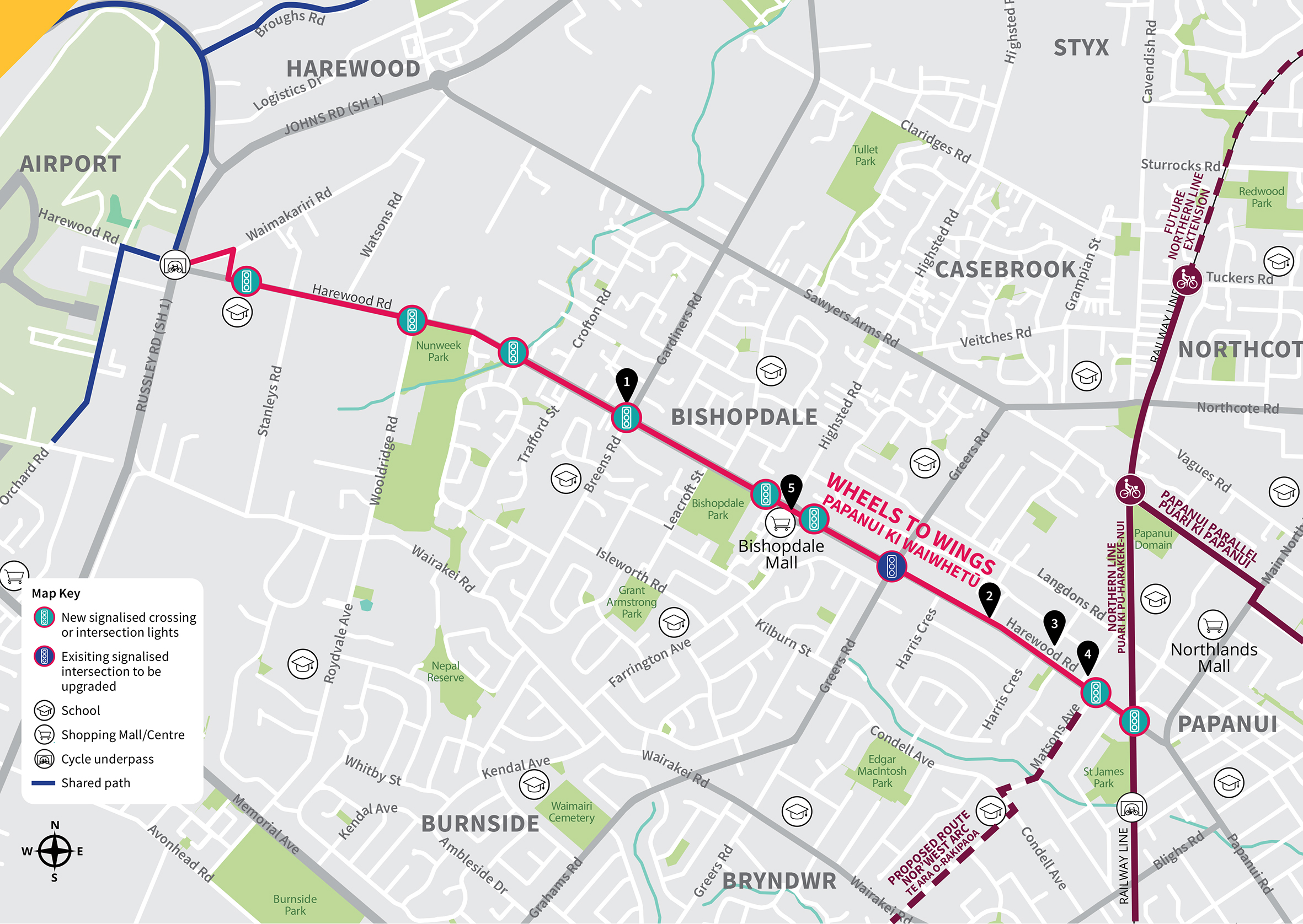
Wheels to Wings map
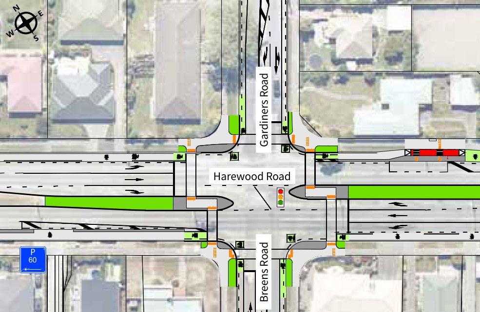
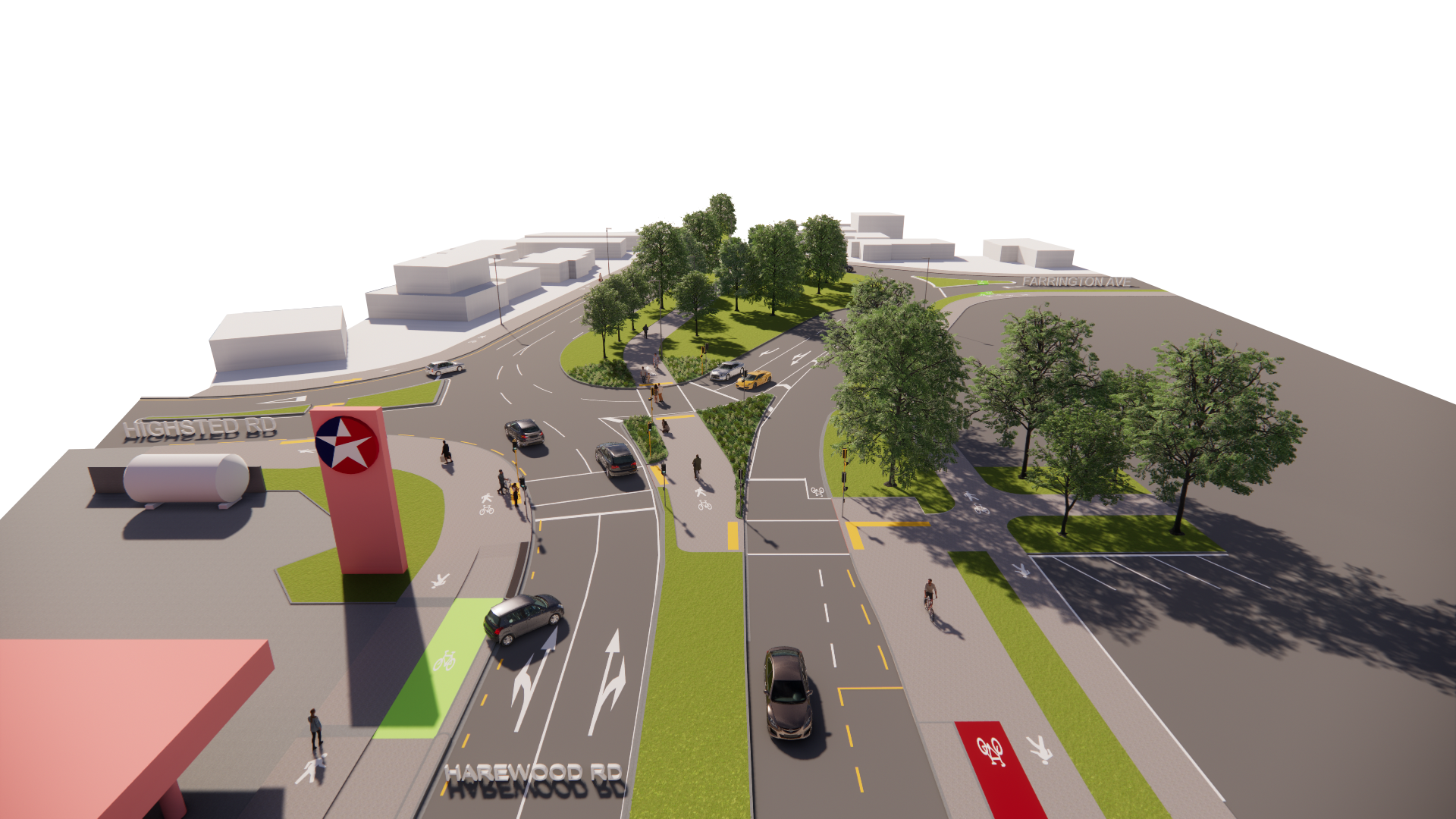
1. Harewood, Gardiners, Breens Road intersection changes
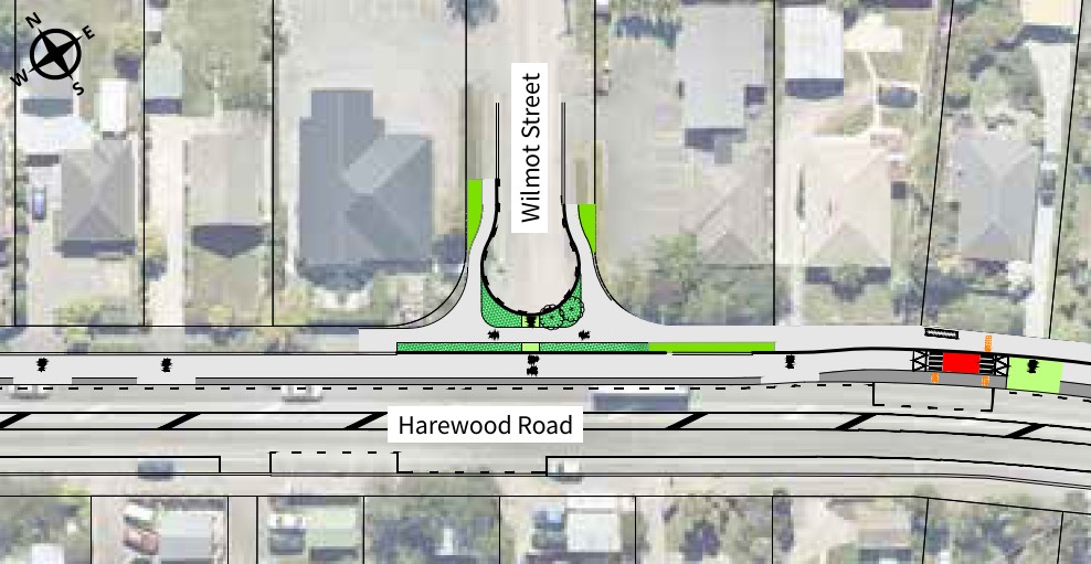
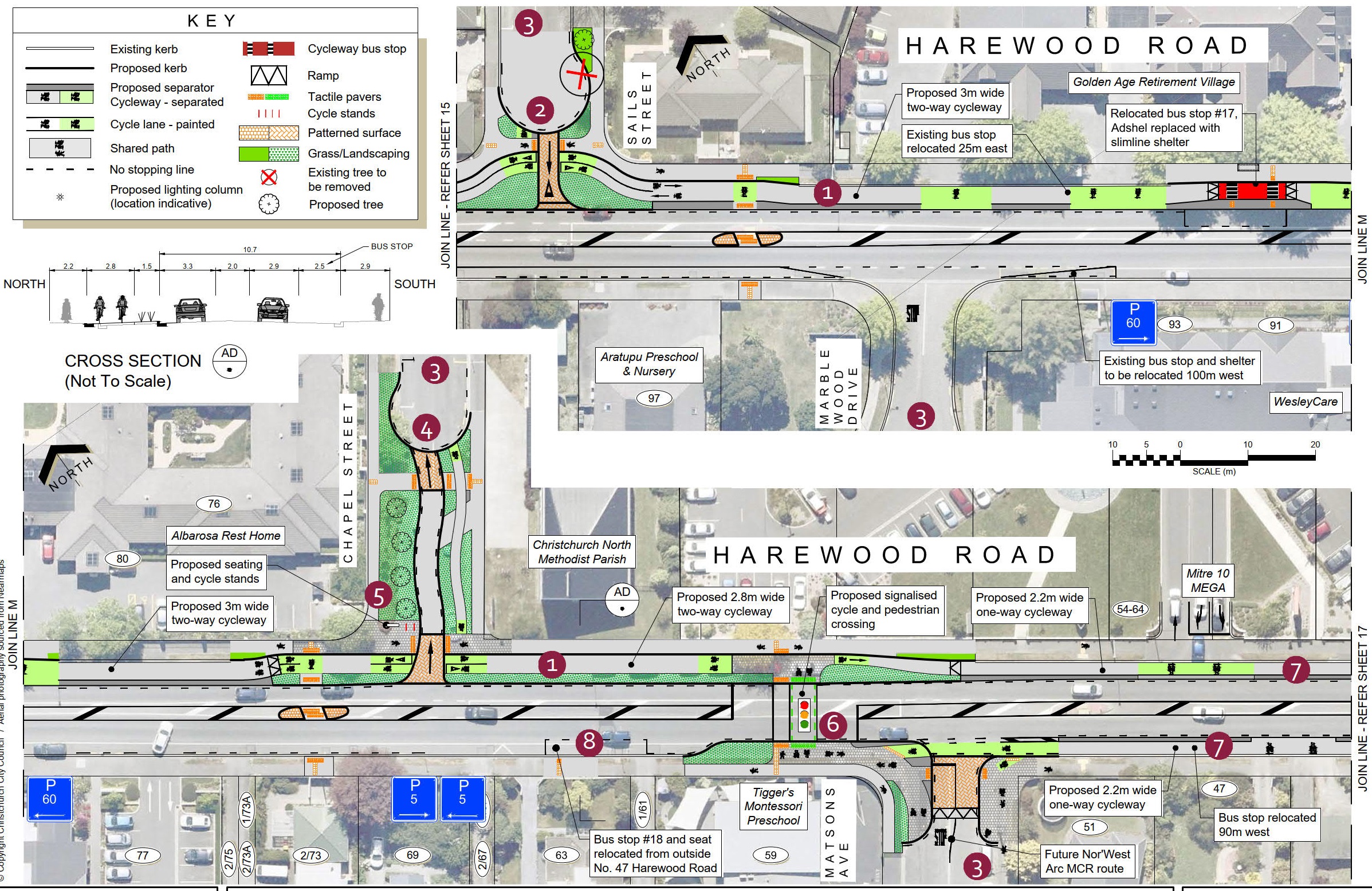
2. Wilmot Street cul-de-sac at Harewood Road
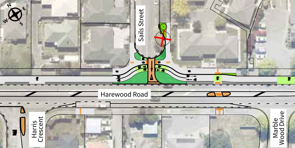
3. Sails Street Harewood Road intersection exit only
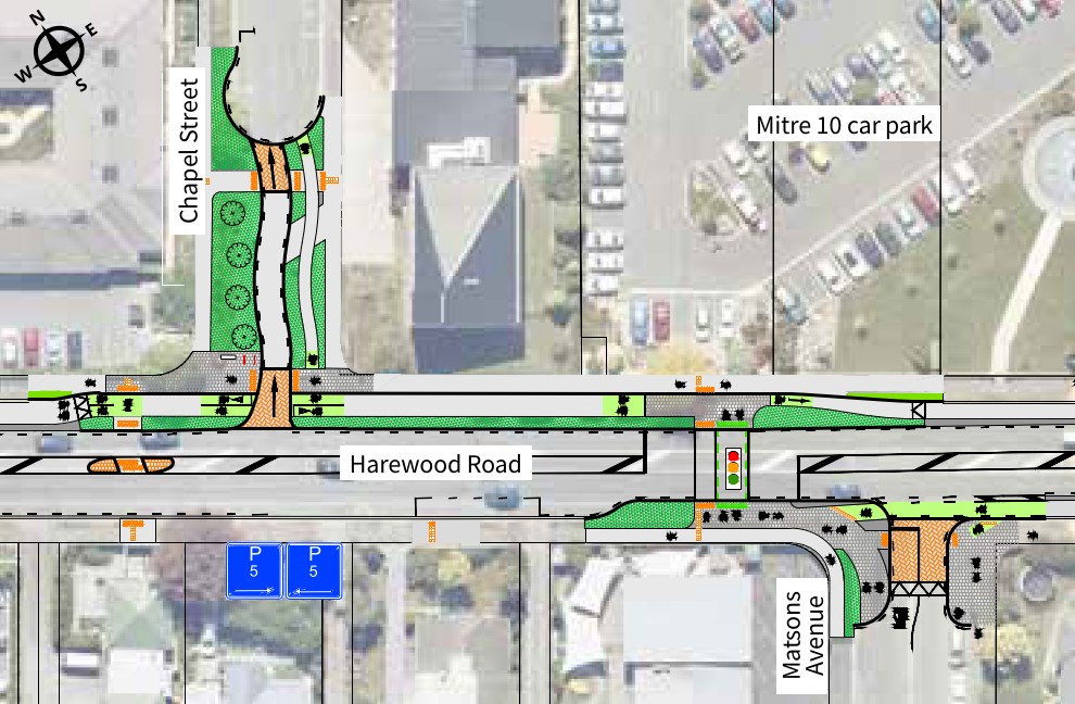
4. Chapel Street intersection with Harewood Road
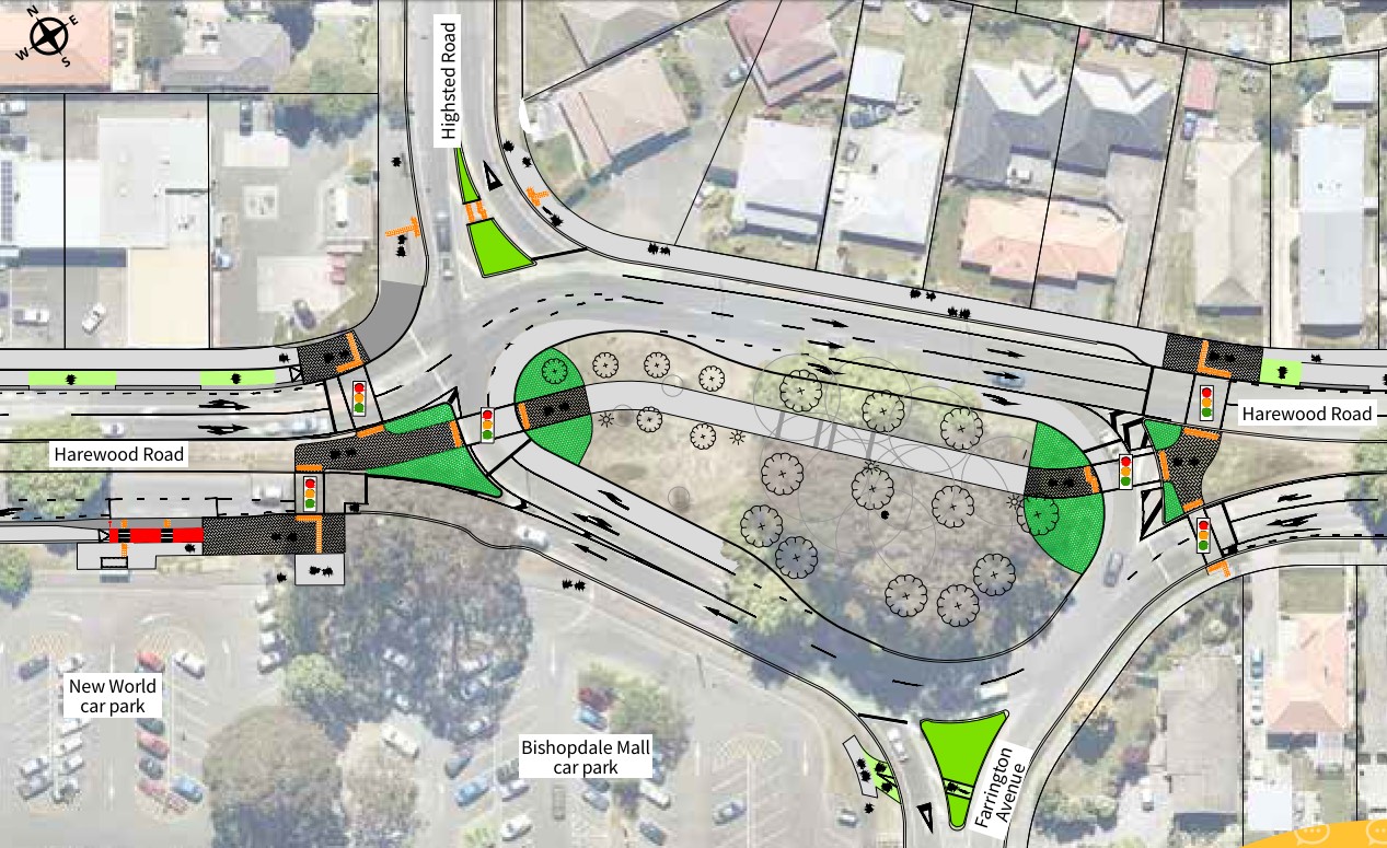
5. Bishopdale Roundabout
Changes to road layouts along the route have been proposed to improve safety for everyone. These changes include new signalised intersections and crossings, and safety improvements to existing intersections.
The four-lane section of Harewood Road is proposed to be reduced to two lanes to make space for cycling and on-street parking. This will also encourage lower speeds and make the road safer for turning drivers and pedestrians to cross. There will be additional lanes at some
intersections to maintain the traffic capacity along Harewood Road.
We’re signalising the Harewood/Wooldridge and Harewood/Gardiners/Breens intersections, partially signalising the Bishopdale roundabout and upgrading the Greers/Harewood intersection. These changes allow for the cycleway and help to improve safety overall.
We’re proposing to cul-de-sac Wilmot Street at Harewood Road, make Sails Street exit only onto Harewood Road and make Chapel Street entry only from Harewood Road. This will improve safety by reducing the amount of traffic turning across the cycleway.
A new signalised crossing outside Harewood Primary School and an extension to the school speed zone are proposed to improve school access.
Parking
We have tried to minimise the removal of on-street parking, however the competing demands for road space mean that some on-street parking will be removed along the route.
The design proposed was chosen to minimise the loss of on-street parking while maintaining safety for people cycling.
In areas of high parking demand we are proposing time-restricted parking on Harewood Road and nearby side streets to help ensure convenient parking is available.
Street lighting
Street lighting will be upgraded along the route to make the cycleway safer and more comfortable to use after dark. This will include the installation of new street lights where the current lighting levels do not meet the requirements for a cycleway or other changes to the road. This will require some new street lights to be installed, at locations to be confirmed in future stages of the project as the design progresses.
Trees
A total of 21 trees are proposed to be removed as part of this project in order to provide space for the cycleway and traffic lanes, improve visibility, and where the trees may pose a risk to people walking or cycling. A total of 56 new trees are proposed to be planted along the route, as shown in the detailed plans, however these are subject to confirming underground services at these locations.
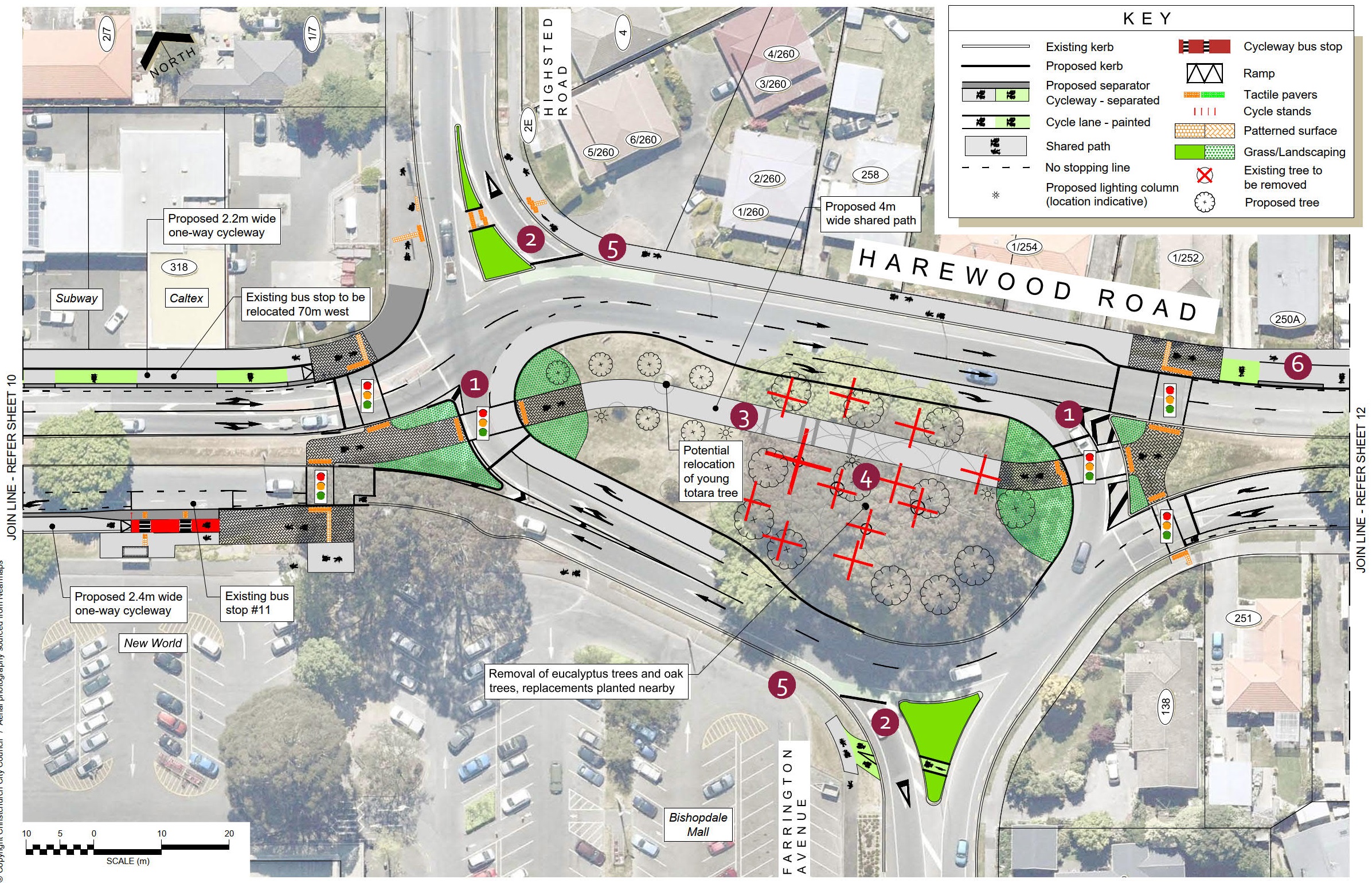
The eucalyptus and oak trees in the Bishopdale Roundabout are proposed to be removed. A shared path is proposed within the roundabout island, and the eucalyptus trees can pose a risk to path users from falling branches. The risk of this is increased due to the removal of several adjacent trees to fit the new path and turning traffic lanes. The remaining oak trees need to be removed as they are interdependent on the surrounding trees, leaving them at risk of becoming unstable as other trees are removed.
Replacement trees are proposed in the roundabout, which include exotic species alongside the path to provide fast-growing shelter, with natives in other parts of the roundabout.
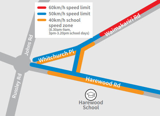
Harewood School Speed Zone map
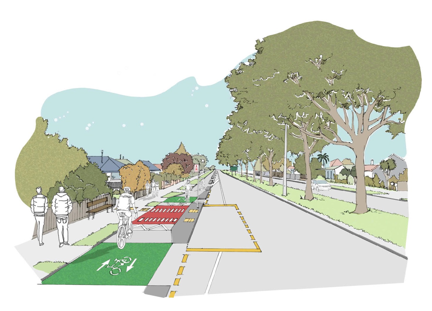
Artist impression looking east outside 230 Harewood Road
Artist impression looking east outside 164 Harewood Road
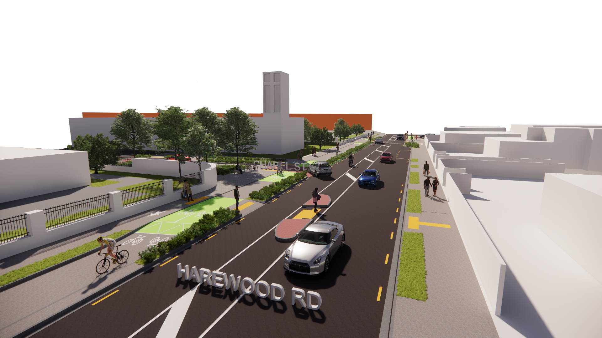
Chapel Street and Harewood Road intersection
Bishopdale Roundabout
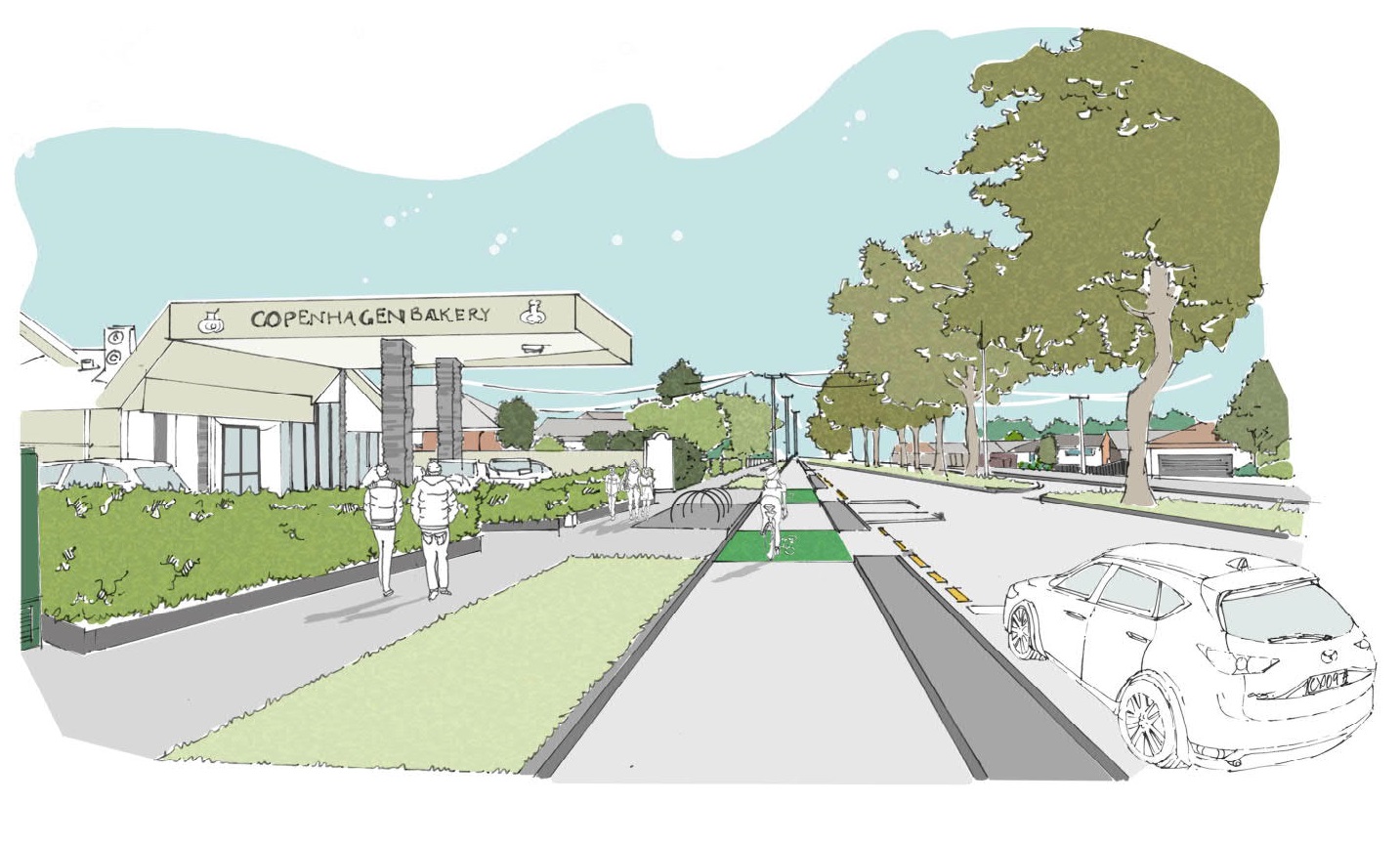
Artist impression looking west outside Copenhagen Bakery
Chapel St east
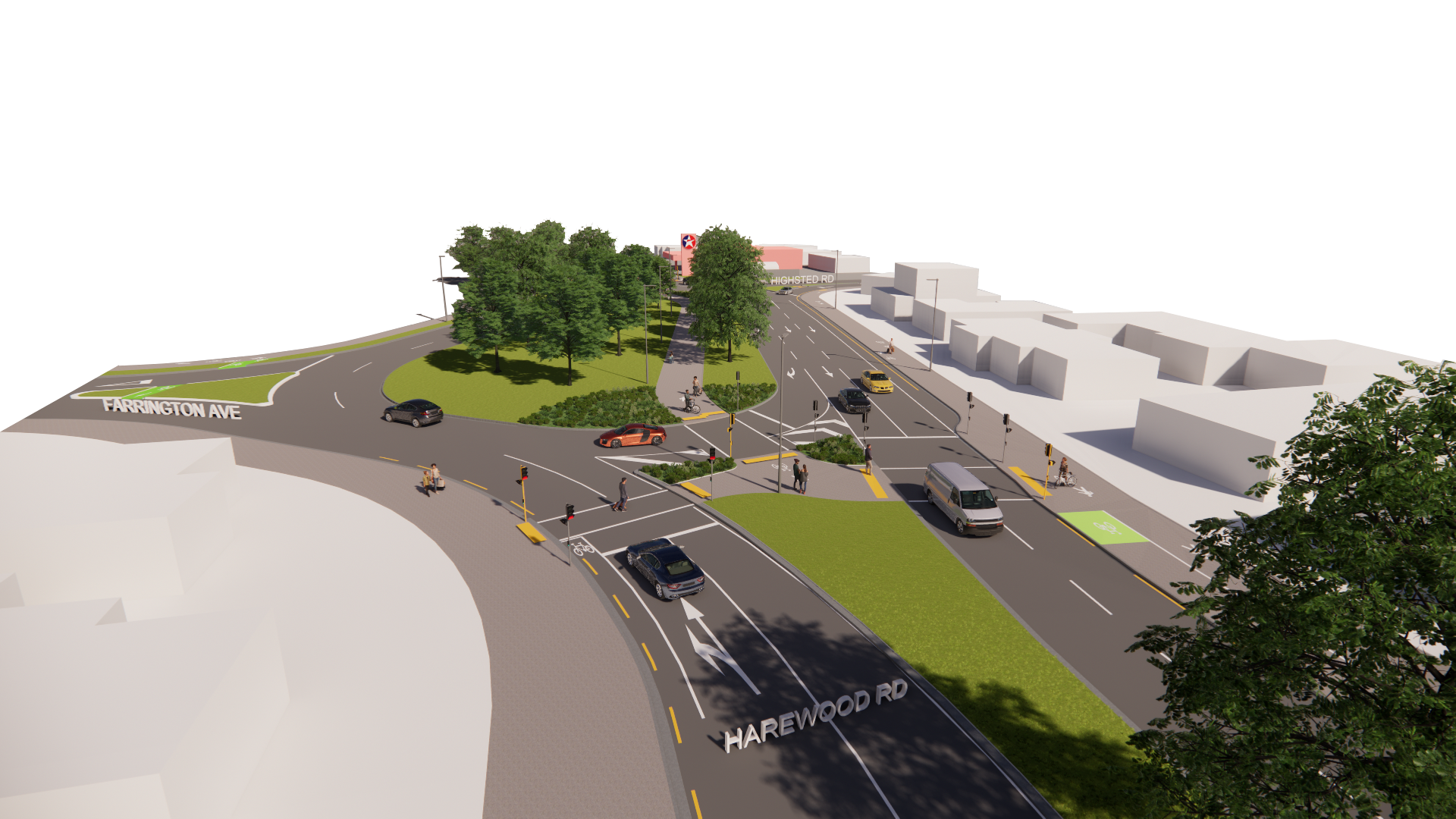
Roundabout east
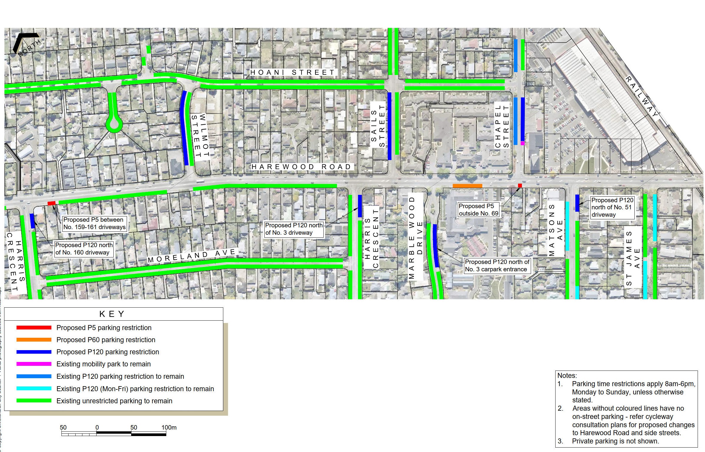
Parking Plan Wheels to Wings
Plans are below the table
Plan number | Features |
| 1 | Whitchurch Place and Waimakariri Road
Street lighting will be upgraded to make the path safer and more comfortable for use after dark. This will include the installation of new street lights at locations to be confirmed in future stages of the project. |
| 2 | Harewood Road - 750 to 714
Raised safety platforms are being used increasingly to manage vehicle speeds at intersections and crossings on arterial roads in New Zealand and overseas. The raised safety platforms proposed for use on Harewood Road are different to the steeper platforms used for traffic calming on local roads, in this case being designed for a maximum comfortable speed of 40 km/h. |
| 3 | Harewood Road - 690 to Watsons Road
|
| 4 | Harewood Road - 658 to 586
|
| 5 | Harewood Road - Nunweek Park to 547
|
| 6 | Harewood Road - 547 to 519
Raised safety platforms are being used increasingly to manage vehicle speeds at intersections and crossings on arterial roads in New Zealand and overseas. The raised safety platforms proposed for use on Harewood Road are different to the steeper platforms used for traffic calming on local roads, in this case being designed for a maximum comfortable speed of 40 km/h. |
| 7 | Harewood Road - Crofton Road to Copenhagen Bakery
Council consulted on and approved a scheme in 2010 to remove a traffic lane in each direction and install cycle lanes on this section of Harewood Road, however, this was never implemented due to the earthquakes. |
| 8 | Harewood Road - Gardiners Road, Breens Road intersection New traffic signals at the intersection with Gardiners and Breens Roads, approved by Council in 2019, are incorporated into the cycleway design. 1.8-2.2m wide one-way separated cycleways run along each side of Harewood Road, removing a traffic lane in each direction. |
| 9 | Harewood Road - 404 to 364
On urban roads with traffic volumes such as those on Harewood Road, it is the intersections that dictate how traffic flows, not the number of lanes between intersections. Removing a traffic lane encourages lower traffic speeds and makes the road safer for drivers and pedestrians to cross. |
| 10 | Harewood Road - 364 to 322
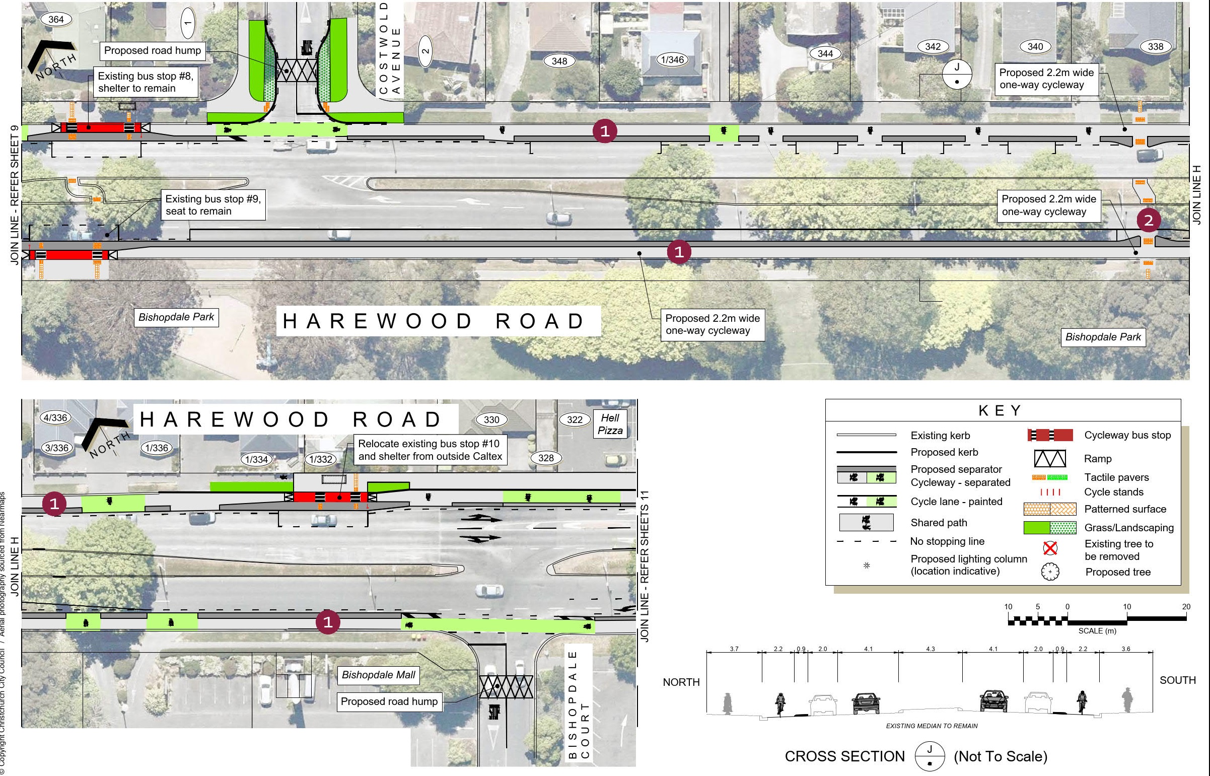
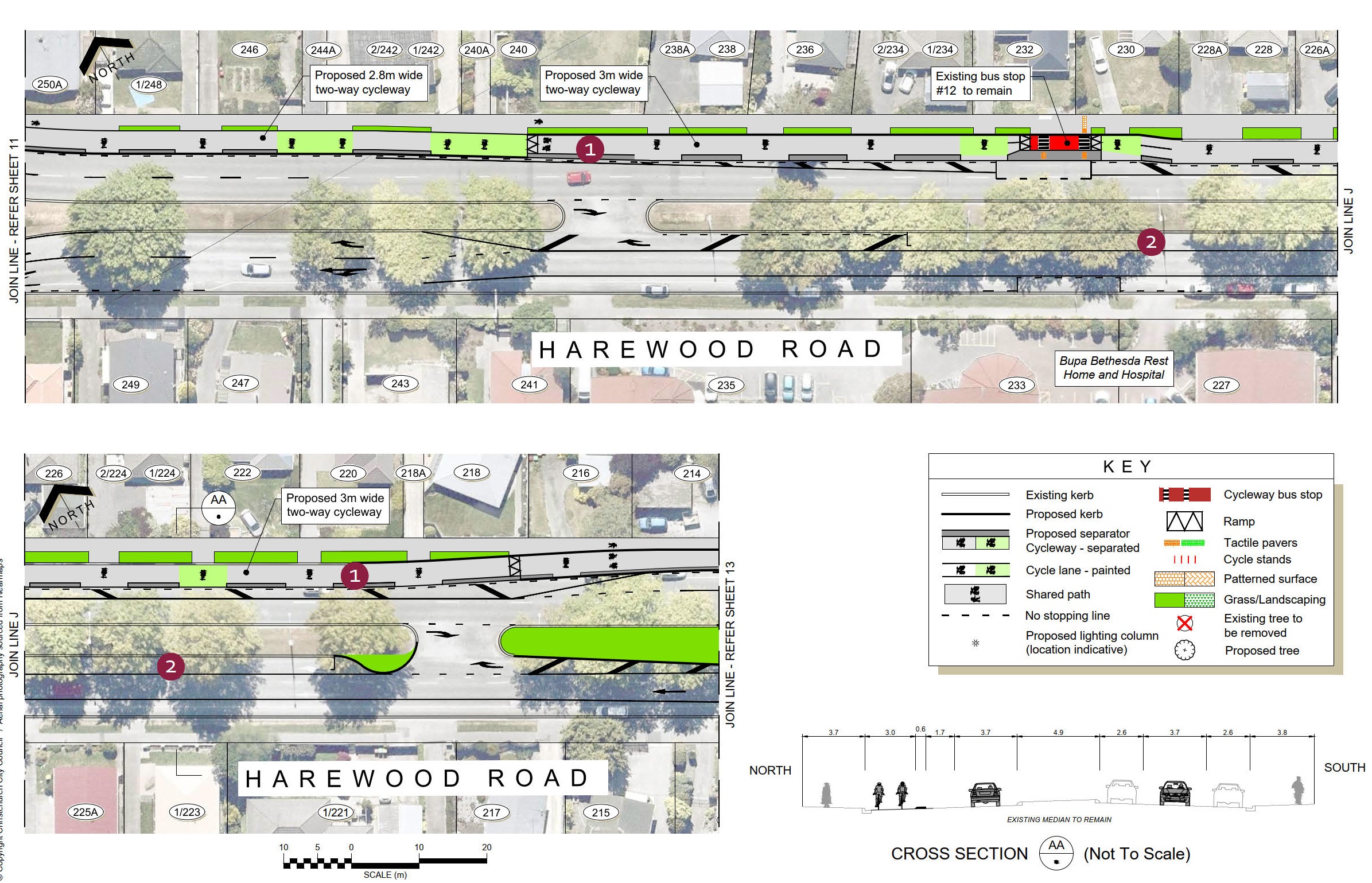
Bus stops alongside separated cycleways feature a raised island between the bus stop and the cycleway. Passengers will step on and off the bus from the raised island. While on-street parking is provided on both sides of the road, the amount provided is reduced to provide adequate visibility for drivers and riders at driveways and side roads, as well as to make other improvements for safety and access at bus stops and pedestrian crossing points. |
| 11 | Bishopdale Roundabout
Multiple design options were investigated for the cycleway to negotiate the roundabout. This option of partially signalising the roundabout provides the least delay for cycleway and road users, while providing safe crossings along the cycle route as well as across Harewood Road. |
| 12 | Harewood Road - 250A to 214
On urban roads with traffic volumes such as those on Harewood Road, it is the intersections that dictate how traffic flows, not the number of lanes between intersections. Removing a traffic lane encourages lower traffic speeds and makes the road safer for drivers and pedestrians to cross. |
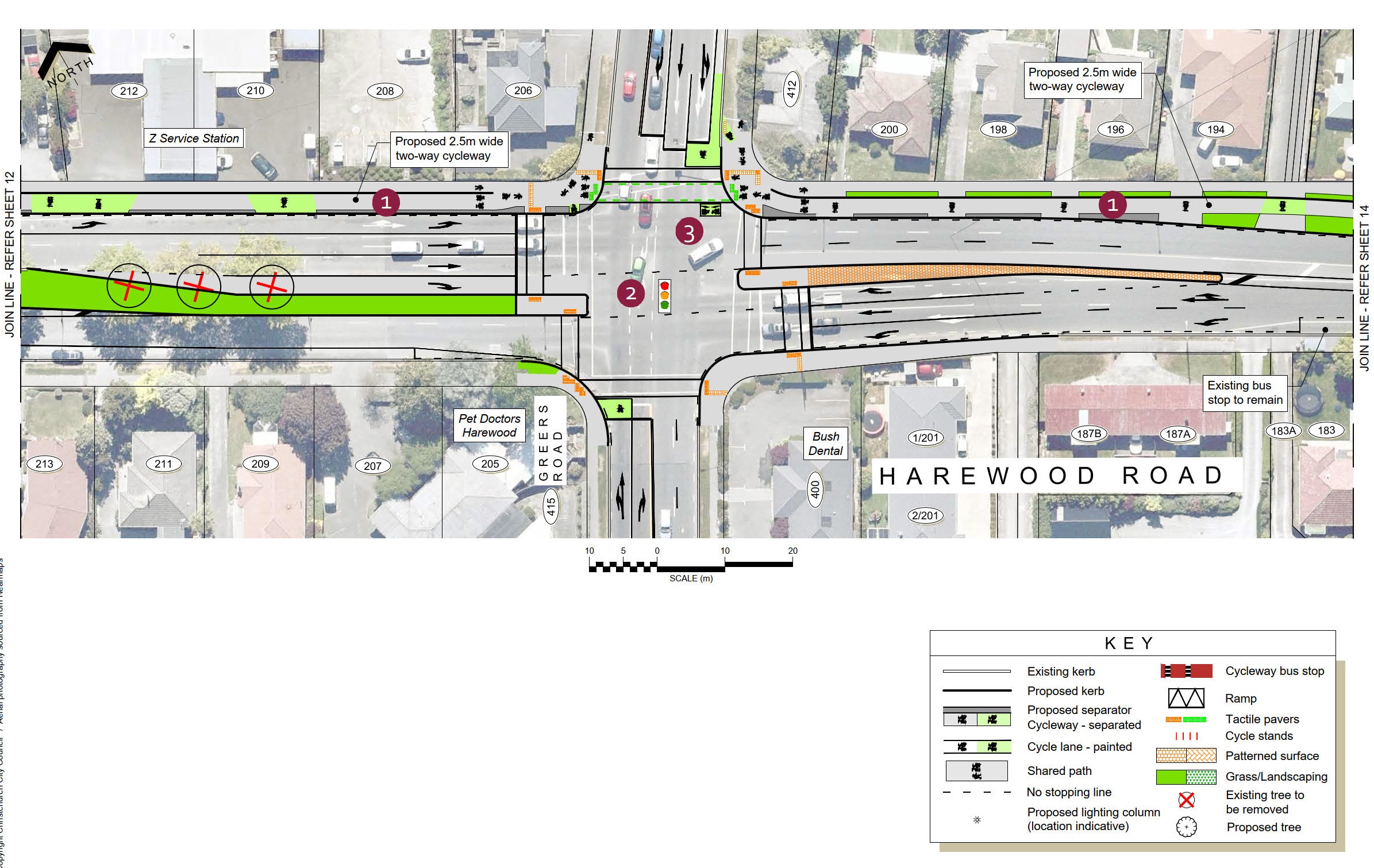
| 13 | Harewood Road and Greers Road intersection
The works at the Greers Road intersection will include safety improvements for people walking and driving as well as cycling. |
| 14 | Harewood Road - 188A to 154
One-way separated cycleways were considered for this section of Harewood Road; however, to fit the required lane widths and the flush median, all on-street parking would have needed to be removed. |
| 15 | Harewood Road - 152 to 108
Access restrictions at Sails and Chapel Streets are also proposed as part of this project. Refer to Sheet 16. Access to and from the surrounding area has been considered as part of the design. |
| 16 | Harewood Road (Sails Street to Mitre 10 MEGA)
|
| 17 | Mitre 10 MEGA to Papanui Road
One-way separated cycleways were selected for east of Matsons Avenue to create a more intuitive facility to help all road users safely navigate this busy area with numerous side roads, the Mitre10 access and junction of three Major Cycle Routes. |
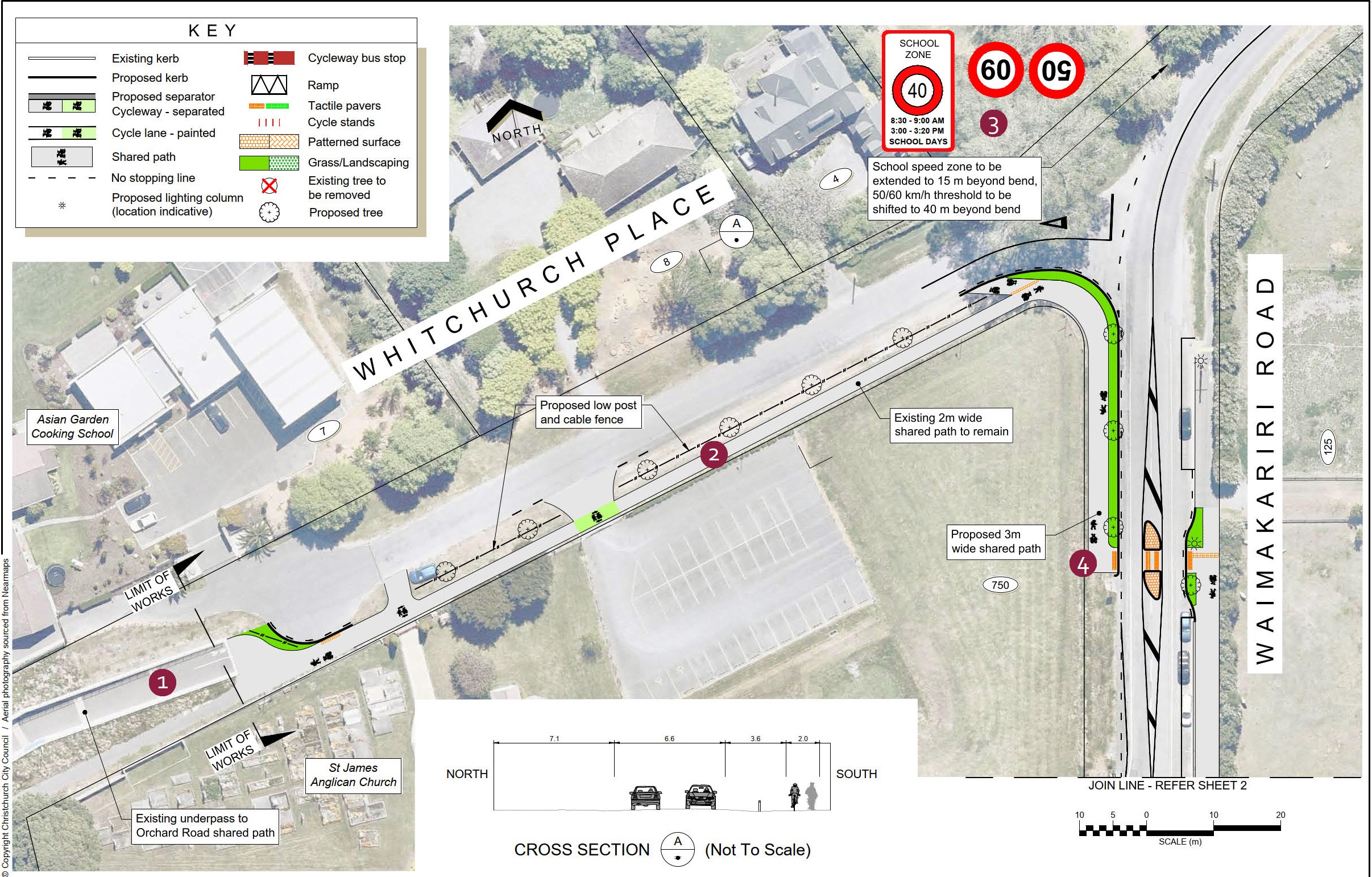
Plan 1 - Whitchurch Place and Waimakariri Road
Plan 2 - 750 to 714 Harewood Road
Plan 3 - 690 Harewood Road to Watsons Road
Plan 4 - 658 to 586 Harewood Road
Plan 5 - Nunweek Park to 547 Harewood Road
Plan 6 - 547 to 519 Harewood Road
Plan 7 - Crofton Road to Copenhagen Bakery
Plan 8 - Harewood Road, Gardiners Road, Breens Road intersec
Plan 9 - 404 to 364 Harewood Road
Plan 10 - 364 to 322 Harewood Road
Plan 11 - Bishopdale Roundabout
Plan 12 - 250A to 214 Harewood Road
Plan 13 - Harewood Road and Greers Road intersection
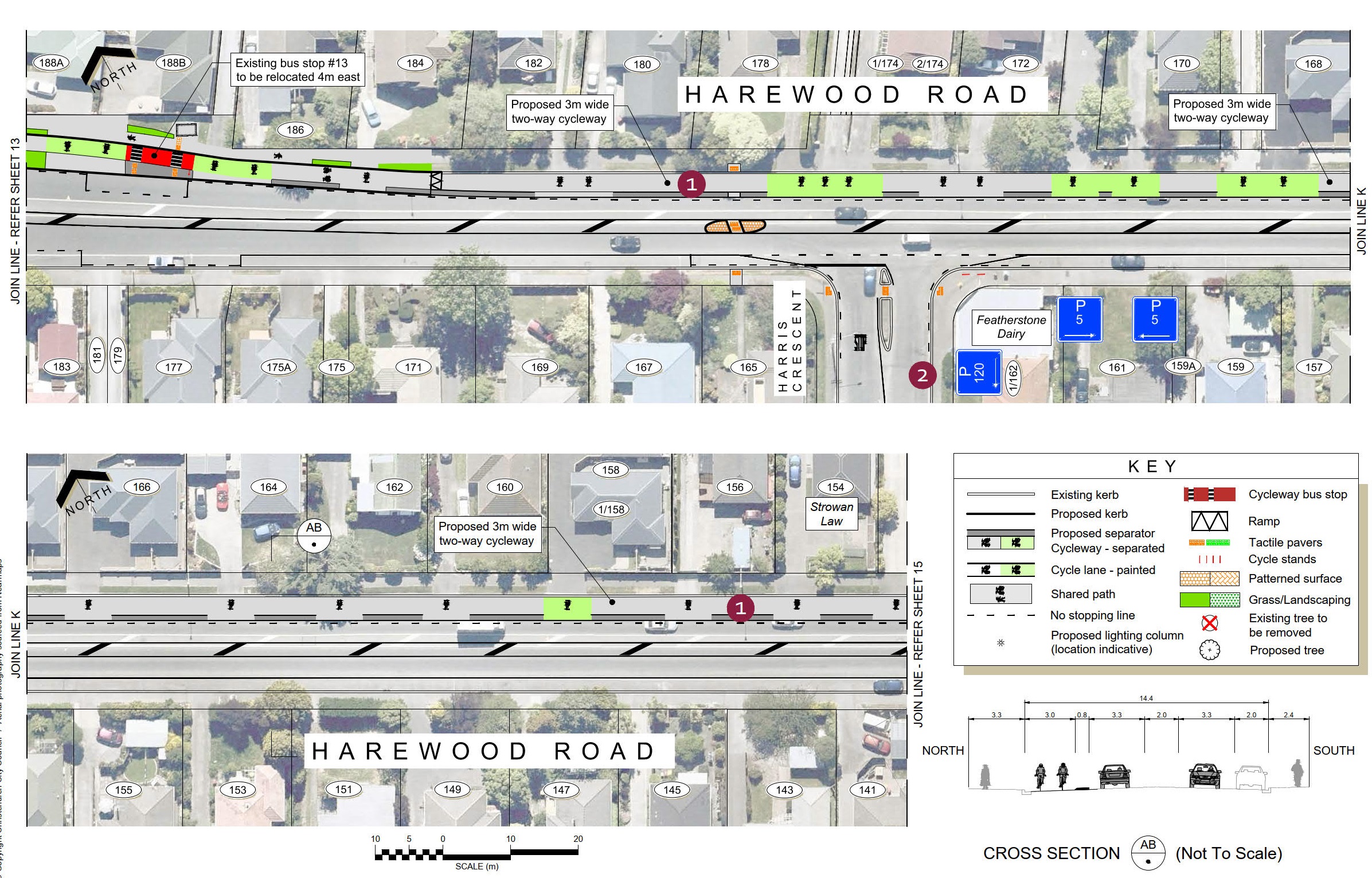
Plan 14 - 188A to 154 Harewood Road
Plan 15 - 152 to 108 Harewood Road
Plan 16 - Harewood Road (Sails Street to Mitre 10 MEGA)
Plan 17 - Mitre 10 MEGA to Papanui Road
We are developing a network of 13 major cycleways all across Christchurch linking shopping centres, businesses, schools, parks and popular recreation destinations all across Christchurch.
Cycleways are a proven way to improve the health of a city, reduce congestion, build stronger local economies and reduce the long-term costs of infrastructure. They are also a key part of our plan to reduce carbon emissions.
The cycleways we have built so far have been well used. A morning count of people biking into the central city showed that 20 per cent more people were biking in March 2020 than a year earlier. This increase follows a pattern of yearly increases since we began building a
network of major cycle routes around the city.
The Major Cycleways are different to other cycle lanes around the city. They are designed to cater to people who don’t feel comfortable riding on the road.


