Partial decision made
Ferry Road is a vital transport route for commuters traveling from the eastern suburbs to the central city.
With approximately 20,000 vehicles traveling this road a day, pedestrians crossing Ferry Road - between Wilsons Road and Aldwins Road - must either wait in the flush median strip or walk to the signalised intersections at Wilsons Road/Moorhouse Ave/Ferry Road or Ensors Road/Aldwins Road/Ferry Road to cross safely. There have also been multiple incidents along this stretch of road involving cars, cyclists and pedestrians.
Pedestrian crossings
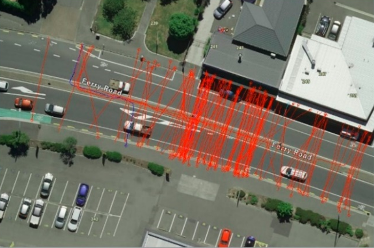
Recently we conducted a pedestrian survey, using a camera, to view how people cross Ferry Road. This data was collected on a Thursday and a Saturday, both surveys were conducted from 7am to 7pm.
The survey determined desire lines, which are the most convenient paths chosen by pedestrians to get from point A to point B.
These desire lines (shown below in red) have been used to determine the most appropriate position for pedestrian refuge islands along Ferry Road.
Proximity to intersections and blind spots have also been taken into consideration.
Pedestrian counts
Pedestrian desire lines


Using this data, we're planning to:
- Install four pedestrian refuge islands at Ferry/Mathesons/Barbour, Ferry/Olliviers, Ferry/Bordesley and Ferry/Ryan intersections. Asphalt speed humps will be installed on the approaches to the refuge islands to slow vehicles down - making it safer for people to cross.
- Install new yellow no-parking lines around the pedestrian refuges.
- This would remove 15 car parks.
- The P10 outside of 268 Ferry Road would move to outside 276 and 278 Ferry Road.
- Repaint two bus stops outside 256 and 290 Ferry Road to make boundary lines clearer
- Install a new stop sign at Mathesons Road and formalise the 'give way' functions at Barbour, Grafton, Osborne and Ryan streets by adding signs and line markings.
Speed humps
No one expects a crash, but people make mistakes – including those who are careful and responsible drivers. We're doing our best to try to reduce crashes but acknowledge that crashes will continue to happen, like when a driver misses a crossing pedestrian.
One way we can prevent serious injury or harm is through speed humps, which are an affordable and effective way to slow vehicles down in high pedestrian areas.
For more detail on what's proposed - check out the plans below.
Matheson Road / Barbour Street / Ferry Road intersection
If you're on a mobile phone, rotate your phone to landscape mode to view the map.
Click on the dots to view a close up of the proposed changes.

Olliviers Road / Ferry Road intersection
If you're on a mobile phone, rotate your phone to landscape mode to view the map.
Click on the dots to view a close up of the proposed changes.

Bordesley Street / Ferry Road intersection
If you're on a mobile phone, rotate your phone to landscape mode to view the map.
Click on the dots to view a close up of the proposed changes.

Ryan Street / Ferry Road intersection
If you're on a mobile phone, rotate your phone to landscape mode to view the map.
Click on the dots to view a close up of the proposed changes.


