Waterways
Planting along waterways will be predominantly native species
Consultation on the Ōpāwaho Heathcote River Planting Plan has now closed. People were able to provide feedback from 29 May to 19 June. Both the Waihoro Spreydon-Cashmere-Heathcote Community Board and Waitai Coastal-Burwood-Linwood Community Board approved the plan with minor amendments recommended after considering community feedback.
Council staff have been working with and supporting volunteer groups, and schools, to plant public spaces along the Ōpāwaho Heathcote river corridor. The purpose of the Ōpāwaho Heathcote River Planting Plan is to provide these volunteer groups, as well future groups, with further areas suitable for restoration planting.
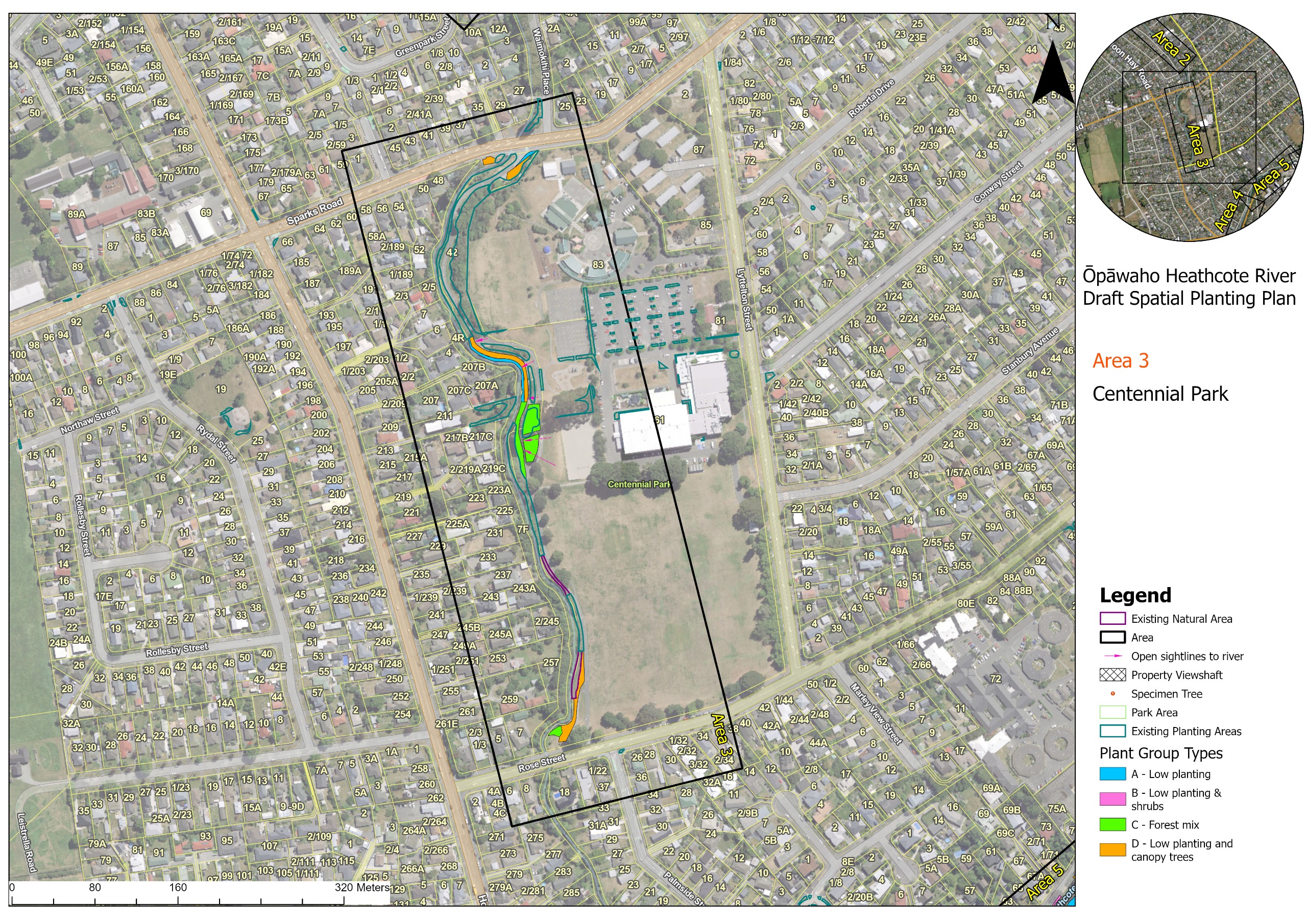
From Tunnel Road in Woolston to Spreydon Domain in Somerfield the plan identifies 24 areas to be planted, and provides guidelines on which plant group types should be incorporated into each of those areas.
The proposal aims to significantly increase planting along the river while balancing other objectives such as the retention of views of the water.
Through the provision of clear planting guidelines and pre-approval of a large number of planting locations, the plan will provide certainty and direction to volunteer community groups and kura (schools) wishing to undertake restoration planting along the river.
The plan also incorporates and aligns with existing approved plans for the awa (river) including:
Click on each of the titles below to see the plant group types and area maps.
Planting along waterways will be predominantly native species
Tree species will be well suited to the local conditions
Trees and plants will be positioned appropriately to allow for flood and debris management
No tree will be planted closer than 3 metres from a pathway
Tree plantings will be structured to retain regular sight lines to pathways and the river.
Trees will be clear of existing underground services and in locations that will not impact on overhead utilities
We are aware that riverside plantings can have a negative impact on some people. These negative impacts can be avoided through carefully selecting the right plants in the right places to complement the local river flows and environment, and provide sight lines through to pathways and the river. We have developed a planting guideline to provide guidance to planting groups on which plant types are appropriate to use in each identified planting area.
The guideline sets out direction on how to choose specific plants for each of the identified planting areas to support Crime Prevention Through Environmental Design (CPTED), access and use of the river and maintenance within the planted sites. The guideline provides general information for all sites, and for some sites there is additional specific advice.
The guideline will also provide a list of plant species appropriate for each planting group type.
We have developed four plant types suitable to plant along the river that meet the objectives of the Urban Forest Plan, and supports a healthy waterway, increased biodiversity and canopy cover, and recognises cultural needs, flood management, and the maintenance of river views from adjacent roads and pathways.
This group are a maximum of 1.2 metres high and primarily consists of plant species that flop over in a flood event. They also allow for good visibility of the river.
This group have a maximum height of 6 metres, include ti kōuka or similar. This group can incorporate harakeke, but it should be used sparingly, in clumps, and located away from the river edge, bridges and river narrowing, and from the edge of paths.
These are plants suitable in combination to create a greater level of biodiversity, more akin with naturally occurring native bush.
Canopy trees are clear trunked trees that allow sightlines beneath or allow for flood water to move around them such as totara and kōwhai.
The following image provides a graphical cross section of plant group types across the river to show example of their preferred location within the river banks and reserves.

From Tunnel Road in Woolston to Spreydon Domain in Somerfield there are 24 areas we have identified for planting. You can view each of the planting areas below or download the pdf of all proposed sites.
Click on any area map below to open it in full screen view. There are buttons at the top of the screen to zoom in on the map and view the proposed plant group types for each area and arrows on either side to scroll between the maps.


![]()
Have questions or want to learn more about a project? Contact us:
| letstalk@ccc.govt.nz |


